IMAGES TAKEN NEAR TO
Quay Brae, DOWNPATRICK, BT30 7TY
Introduction
This page details the photographs taken nearby to Quay Brae, BT30 7TY by members of the Geograph project.
The Geograph project started in 2005 with the aim of publishing, organising and preserving representative images for every square kilometre of Great Britain, Ireland and the Isle of Man.

There are currently over 7.5m images from over14,400 individuals and you can help contribute to the project by visiting https://www.geograph.org.uk
Image Map
Images are licensed for reuse under creativecommons.org/licenses/by-sa/2.0
Notes
- Clicking on the map will re-center to the selected point.
- The higher the marker number, the further away the image location is from the centre of the postcode.
Image Listing (78 Images Found)
Images are licensed for reuse under creativecommons.org/licenses/by-sa/2.0
Image
Details
Distance
1
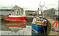
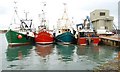
Trawlers at Ardglass (7)
See Image The trawlers “Sea Mourne” (left) and “Our James” at Ardglass.
Image: © Albert Bridge
Taken: 7 Jul 2008
0.01 miles
2
The Harbour, Ardglass
Ice has taken control here, as the temperature barely reaches freezing point.
Image: © Dean Molyneaux
Taken: 21 Dec 2010
0.01 miles
3
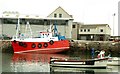
The "Sea Mourne" at Ardglass
See Image In the week since the last photo the “Sea Mourne” has received a fresh coat of paint.
Image: © Albert Bridge
Taken: 14 Jul 2008
0.02 miles
4
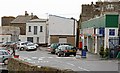
Shops, Ardglass (2)
See Image The Spar overlooking the harbour has been there for more than a few years. It includes a post office.
Image: © Albert Bridge
Taken: 4 Dec 2007
0.02 miles
5
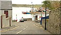
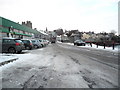
Quay Brae, Ardglass
A short and steep street running from Kildare Street to the harbour.
Image: © Albert Bridge
Taken: 13 Mar 2009
0.03 miles
6
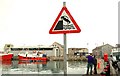
Road sign, Ardglass
A “quayside” sign at Ardglass harbour. The row of bollards should prevent a re-enactment of the scene on the sign.
Image: © Albert Bridge
Taken: 13 Mar 2009
0.04 miles
7
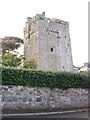
Jordan's Castle, Quay Street, Ardglass
This former defensive tower house was built in the 15thC. In Elizabethan times, its owner, Simon Jordan, endured a three year siege by the men of rebellious Hugh O'Neill, the Earl of Tyrone. The siege was finally lifted by the arrival of the English fleet in 1601. With the pacification of the area in Georgian times, the tower-house lost its purpose and was left to fall into disrepair. Its purchased in 1911 by a rich lawyer who was willing to spend money on its restoration saved Jordan's Castle from being demolished. The old tower house is now cared for by the Northern Ireland Assembly.
Image: © Eric Jones
Taken: 20 Aug 2009
0.04 miles
8
Ardglass Harbour viewed from Kildare Street
The tower in the foreground is Jordan's Castle - which is a tower-house rather than a true castle. It is named after Simon Jordan who withstood a long siege in the tower in 1601.
Image: © Eric Jones
Taken: 20 Aug 2009
0.04 miles
9
Trawlers at Ardglass (5)
See Image With fishing prohibited at weekends fishery harbours are inevitably full. This is a selection of the boats in Ardglass harbour. The ice plant is on the right. Continue to Image
Image: © Albert Bridge
Taken: 23 Feb 2008
0.05 miles
10
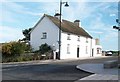
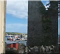
A beautiful white painted house at Castle Place
This stands at the junction with Bri na Ce (Quay Brae), the local name for this part of Kildare Street.
Image: © Eric Jones
Taken: 20 Aug 2009
0.05 miles