IMAGES TAKEN NEAR TO
Tollumgrange Road, DOWNPATRICK, BT30 7TD
Introduction
This page details the photographs taken nearby to Tollumgrange Road, BT30 7TD by members of the Geograph project.
The Geograph project started in 2005 with the aim of publishing, organising and preserving representative images for every square kilometre of Great Britain, Ireland and the Isle of Man.

There are currently over 7.5m images from over14,400 individuals and you can help contribute to the project by visiting https://www.geograph.org.uk
Image Map
Images are licensed for reuse under creativecommons.org/licenses/by-sa/2.0
Notes
- Clicking on the map will re-center to the selected point.
- The higher the marker number, the further away the image location is from the centre of the postcode.
Image Listing (5 Images Found)
Images are licensed for reuse under creativecommons.org/licenses/by-sa/2.0
Image
Details
Distance
1
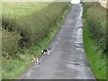
Two friendly residents of Tollumgrange Townland
These two sociable fellows accompanied me up the brae before disappearing into one of the houses.
Image: © Eric Jones
Taken: 23 Sep 2011
0.11 miles
2
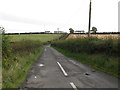
The Tollumgrange Road east of the Crew Road Crossroads
This road leads to the hamlet of Churchtown.
Image: © Eric Jones
Taken: 23 Sep 2011
0.14 miles
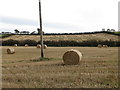
3
Lenticular altocumulus clouds above Tollumgrange Lower
Image: © Eric Jones
Taken: 23 Sep 2011
0.17 miles
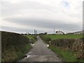
5
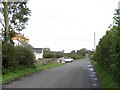
Minor crossroads on the Crew Road
The car passing through the junction is crossing Crew Road from Ballybrannagh Road to enter Tollumgrange Road.
Image: © Eric Jones
Taken: 23 Sep 2011
0.24 miles