IMAGES TAKEN NEAR TO
Church Road, DOWNPATRICK, BT30 7SZ
Introduction
This page details the photographs taken nearby to Church Road, BT30 7SZ by members of the Geograph project.
The Geograph project started in 2005 with the aim of publishing, organising and preserving representative images for every square kilometre of Great Britain, Ireland and the Isle of Man.

There are currently over 7.5m images from over14,400 individuals and you can help contribute to the project by visiting https://www.geograph.org.uk
Image Map
Images are licensed for reuse under creativecommons.org/licenses/by-sa/2.0
Notes
- Clicking on the map will re-center to the selected point.
- The higher the marker number, the further away the image location is from the centre of the postcode.
Image Listing (17 Images Found)
Images are licensed for reuse under creativecommons.org/licenses/by-sa/2.0
Image
Details
Distance
1
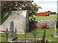
Ruined farm shed viewed from St Mary's Churchyard
The structure on the left is the Gilchrist family vault.
Image: © Eric Jones
Taken: 23 Sep 2011
0.01 miles
3
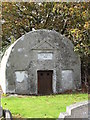
The Gilchrist Vault at St Mary's Church (CoI)
This vault dates from 1881.
Image: © Eric Jones
Taken: 23 Sep 2011
0.06 miles
4
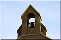
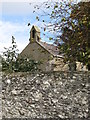
St Mary's church near Ardglass
See Image The bell.
Image: © Albert Bridge
Taken: 6 Nov 2007
0.06 miles
5
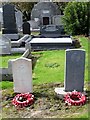
Service graves at St Mary's CoI Church, Dunsford
The stone on the right marks the grave of an unknown seaman from the HMS Bayano torpedoed in the North Channel in 1915 with great loss of life.
http://www.wrecksite.eu/wreck.aspx?366
That on the left marks the grave of RAF Cpl. L. Archibald who died in 1959 at the young age of 19. He was presumably stationed at nearby RAF Bishop's Court.
Image: © Eric Jones
Taken: 23 Sep 2011
0.06 miles
6
St Mary's church near Ardglass (1)
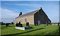
St Mary’s (CoI) parish church at Dunsford (“Dunsfort” on the OS map) dates from 1791. There is an indication that there was a pre-reformation church on the site in 1194.
Image: © Albert Bridge
Taken: 6 Nov 2007
0.07 miles
7
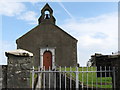
St Mary's (CoI) Church, Dunsford
This is an Anglican Church.
Image: © Eric Jones
Taken: 23 Sep 2011
0.07 miles
8
St Mary's Anglican Church, Dunsford
Like the nearby Catholic chapel of the same name, St Mary's Anglican church was built in 1791. It occupies the site of ruined medieval church. The rector is the Very Rev Henry Hull, the Dean of Downpatrick Cathedral, who also has charge of six other churches on the Lecale Peninsula.
Image: © Eric Jones
Taken: 23 Sep 2011
0.07 miles
9
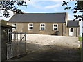
St Mary's (CoI) Parish Hall, Dunsford
This is located next to the parish church.
Image: © Eric Jones
Taken: 23 Sep 2011
0.09 miles
10
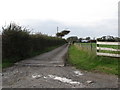
Private lane leading to Dunsford Hall Farm
Image: © Eric Jones
Taken: 23 Sep 2011
0.10 miles