IMAGES TAKEN NEAR TO
Ardtole Road, DOWNPATRICK, BT30 7SL
Introduction
This page details the photographs taken nearby to Ardtole Road, BT30 7SL by members of the Geograph project.
The Geograph project started in 2005 with the aim of publishing, organising and preserving representative images for every square kilometre of Great Britain, Ireland and the Isle of Man.

There are currently over 7.5m images from over14,400 individuals and you can help contribute to the project by visiting https://www.geograph.org.uk
Image Map
Images are licensed for reuse under creativecommons.org/licenses/by-sa/2.0
Notes
- Clicking on the map will re-center to the selected point.
- The higher the marker number, the further away the image location is from the centre of the postcode.
Image Listing (17 Images Found)
Images are licensed for reuse under creativecommons.org/licenses/by-sa/2.0
Image
Details
Distance
1
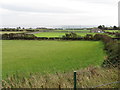
The new Ardglass GAA Ground at Ardtole
This view was taken from the ruined Ardtole Church.
Image: © Eric Jones
Taken: 23 Sep 2011
0.05 miles
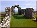
2
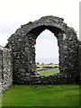
The east window of the ruined Ardtole Church
The North Irish can be seen in the background. The medieval church must have formed a familiar landmark to mariners before the advent of modern navigation instruments.
Image: © Eric Jones
Taken: 23 Sep 2011
0.09 miles
3
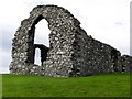
The ruined Ardtole Church from the east
The gable end is almost complete and gives an idea of the height and width of the original church.
Image: © Eric Jones
Taken: 23 Sep 2011
0.09 miles
4
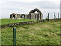
The ruined Ardtole Church from the access path
Image: © Eric Jones
Taken: 23 Sep 2011
0.10 miles
5
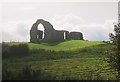
The ruined St Nicholas Church at Ardtole, Ardglass
It is said that this church was abandoned in the 15th C following a massacre of the congregation by the McCartan clan.
http://www.wiki.ie/wiki/Ardtole_Church
Image: © Eric Jones
Taken: 20 Aug 2009
0.12 miles
6
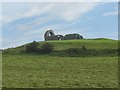
Ardtole's ruined St Nicholas Church from the A2
Image: © Eric Jones
Taken: 20 Aug 2009
0.12 miles
7
St. Nicholas' Church, Ardtole (ruins)
The ruins of St. Nicholas' Church at Ardtole - between Ardglass and Chapeltown.
Image: © Dean Molyneaux
Taken: 10 Mar 2007
0.13 miles
8
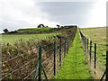
Fenced path leading uphill to the ruined medieval St Nicholas' Church at Ardtole
The ruined church is in the care of the Environment and Heritage Service.
Image: © Eric Jones
Taken: 23 Sep 2011
0.14 miles
9
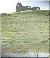
Flooded hay field below the ruined Ardtole Church, Ardglass
This is the result of the day's heavy thunder storms.
Image: © Eric Jones
Taken: 20 Aug 2009
0.14 miles