IMAGES TAKEN NEAR TO
Greenhill, DOWNPATRICK, BT30 7RU
Introduction
This page details the photographs taken nearby to Greenhill, BT30 7RU by members of the Geograph project.
The Geograph project started in 2005 with the aim of publishing, organising and preserving representative images for every square kilometre of Great Britain, Ireland and the Isle of Man.

There are currently over 7.5m images from over14,400 individuals and you can help contribute to the project by visiting https://www.geograph.org.uk
Image Map
Images are licensed for reuse under creativecommons.org/licenses/by-sa/2.0
Notes
- Clicking on the map will re-center to the selected point.
- The higher the marker number, the further away the image location is from the centre of the postcode.
Image Listing (46 Images Found)
Images are licensed for reuse under creativecommons.org/licenses/by-sa/2.0
Image
Details
Distance
2
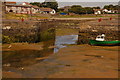
Ardglass harbour
There are three distinct parts to Ardglass harbour – most of it is in J5637. This part, which is normally used only by boats laid up, is probably the oldest and is in J5537. It dries at low water.
Image: © Albert Bridge
Taken: 17 Jul 2006
0.12 miles
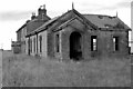
3
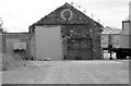
Ardglass Goods Shed
Ardglass Goods Shed, opened 08-07-1892, closed to all traffic, (goods and passenger) 16-01-1950. The station was at the end of the branch line from Downpatrick.
Image: © Wilson Adams
Taken: 13 Jul 2003
0.12 miles
4
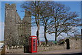
Jordan's Castle, Ardglass (1)
Jordan's Castle is a tower house built in the 15th century (the exact date does not seem to be known). Ardglass was an important port and town in the Anglo-Norman Earldom of Ulster and its old street pattern still exists making it difficult to show the castle without intrusions. It was restored in the early 20th century and is now in state care. It is not shown on the OS map although there is a reference to “Castles” in an adjacent square. This is the view from Kildare Street.
Image: © Albert Bridge
Taken: 18 Apr 2007
0.12 miles
5
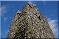
Jordan's Castle, Ardglass (2)
See Image This is a closer view of the tower.
Image: © Albert Bridge
Taken: 18 Apr 2007
0.12 miles
6
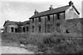
Ardglass Station
Ardglass Station, opened 08-07-1892, closed to all traffic, (goods and passenger) 16-01-1950. The station was at the end of the branch line from Downpatrick.
The tall building in the centre of the photo, might have been the station masters house, (not sure about this).
Image: © Wilson Adams
Taken: 13 Jul 2003
0.12 miles
7
Ardglass Station
Ardglass Station, opened 08-07-1892, closed to all traffic, (goods and passenger) 16-01-1950. The station was at the end of the branch line from Downpatrick.
Image: © Wilson Adams
Taken: 13 Jul 2003
0.12 miles
8
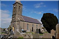
Parish church of St Nicholas, Ardglass
There was a Catholic Church on this site in 1306 but it was in ruins in 1622. The present (CoI) church of St. Nicholas was built on the original site in 1813. In 1839 the north transept was added to accommodate the coastguards and other officials stationed in Ardglass. The cramped nature of the site means that the spire cannot be shown.
Image: © Albert Bridge
Taken: 18 Apr 2007
0.12 miles
9
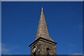
The spire of the parish church of St Nicholas, Ardglass
See Image This is the spire.
Image: © Albert Bridge
Taken: 18 Apr 2007
0.12 miles
10
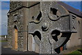
Celtic cross, Ardglass
See Image This memorial, in the graveyard, in the form of a Celtic cross is close to the side door of the church.
Image: © Albert Bridge
Taken: 18 Apr 2007
0.12 miles