IMAGES TAKEN NEAR TO
Branneys Lane, DOWNPATRICK, BT30 7RE
Introduction
This page details the photographs taken nearby to Branneys Lane, BT30 7RE by members of the Geograph project.
The Geograph project started in 2005 with the aim of publishing, organising and preserving representative images for every square kilometre of Great Britain, Ireland and the Isle of Man.

There are currently over 7.5m images from over14,400 individuals and you can help contribute to the project by visiting https://www.geograph.org.uk
Image Map
Images are licensed for reuse under creativecommons.org/licenses/by-sa/2.0
Notes
- Clicking on the map will re-center to the selected point.
- The higher the marker number, the further away the image location is from the centre of the postcode.
Image Listing (115 Images Found)
Images are licensed for reuse under creativecommons.org/licenses/by-sa/2.0
Image
Details
Distance
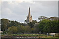
1
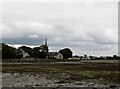
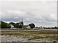
View across Killough Harbour towards St Ann's CoI Church
Image: © Eric Jones
Taken: 20 Jul 2011
0.02 miles
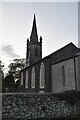
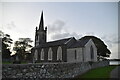
2
Killough Parish Church (Church of Ireland)
St Anne's Church is a Chapel of Ease, the present building dating from 1815. Killough however is a predominantly Roman Catholic community, with fewer than 7 per cent being Protestants.
Image: © Eric Jones
Taken: 20 Jul 2011
0.02 miles
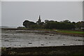
4
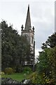
St Anne's Parish Church
Grade II listed.
Image: © N Chadwick
Taken: 29 Oct 2021
0.02 miles

9
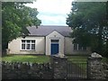
Killough Youth and Community Hall, Main Street, Killough
Image: © Eric Jones
Taken: 20 Aug 2009
0.03 miles