IMAGES TAKEN NEAR TO
West Point, DOWNPATRICK, BT30 7QT
Introduction
This page details the photographs taken nearby to West Point, BT30 7QT by members of the Geograph project.
The Geograph project started in 2005 with the aim of publishing, organising and preserving representative images for every square kilometre of Great Britain, Ireland and the Isle of Man.

There are currently over 7.5m images from over14,400 individuals and you can help contribute to the project by visiting https://www.geograph.org.uk
Image Map
Images are licensed for reuse under creativecommons.org/licenses/by-sa/2.0
Notes
- Clicking on the map will re-center to the selected point.
- The higher the marker number, the further away the image location is from the centre of the postcode.
Image Listing (43 Images Found)
Images are licensed for reuse under creativecommons.org/licenses/by-sa/2.0
Image
Details
Distance
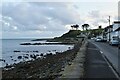
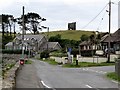
1
Houses at West Point, Killough, viewed from the Point Road
Image: © Eric Jones
Taken: 20 Jul 2011
0.03 miles
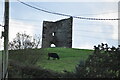
2
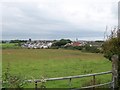
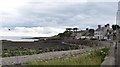
The southern and western outskirts of Killough
This view is taken from the Point Road.
Image: © Eric Jones
Taken: 20 Jul 2011
0.05 miles
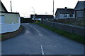
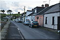
4
The eastern end of Point Road
Here the Point Road, which links the village of Killough with St John's Point Lighthouse, joins Fisherman's Row at the southern end of the village of Killough.
Image: © Eric Jones
Taken: 20 Jul 2011
0.07 miles
5
The junction of Fisherman's Row and Point Road at Killough
Image: © Eric Jones
Taken: 20 Jul 2011
0.08 miles
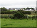
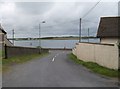
7
The Fisherman's Row foreshore at Killough
Image: © Eric Jones
Taken: 20 Jul 2011
0.09 miles