IMAGES TAKEN NEAR TO
Ballywoodan Road, DOWNPATRICK, BT30 7PE
Introduction
This page details the photographs taken nearby to Ballywoodan Road, BT30 7PE by members of the Geograph project.
The Geograph project started in 2005 with the aim of publishing, organising and preserving representative images for every square kilometre of Great Britain, Ireland and the Isle of Man.

There are currently over 7.5m images from over14,400 individuals and you can help contribute to the project by visiting https://www.geograph.org.uk
Image Map
Images are licensed for reuse under creativecommons.org/licenses/by-sa/2.0
Notes
- Clicking on the map will re-center to the selected point.
- The higher the marker number, the further away the image location is from the centre of the postcode.
Image Listing (6 Images Found)
Images are licensed for reuse under creativecommons.org/licenses/by-sa/2.0
Image
Details
Distance
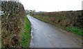
1
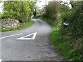
The western end of Ballywoodan Road
Ballywoodan Road links Bishops Court Road with the A2 coastal road.
Image: © Eric Jones
Taken: 20 Sep 2011
0.17 miles
2
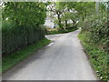
Bishops Court Road at its junction with Ballywoodan Road
Image: © Eric Jones
Taken: 20 Sep 2011
0.18 miles
3
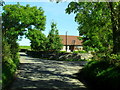
Bishops Court Road, Ballywoodan
At the junction with the Ballywoodan Road.
Image: © Dean Molyneaux
Taken: 13 Sep 2009
0.19 miles
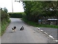
5
The Ballywoodan Road near Ballyhornan
The Ballywoodan Road is another of the narrow roads which abound in this area. The former RAF Bishopscourt is just to the south.
Image: © Albert Bridge
Taken: 4 Dec 2007
0.22 miles
6
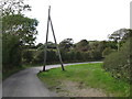
Curving bend in Bishops Court Road
Corner-cutting is deterred by the telephone poles.
Image: © Eric Jones
Taken: 20 Sep 2011
0.24 miles