IMAGES TAKEN NEAR TO
Black Causeway Road, DOWNPATRICK, BT30 7LX
Introduction
This page details the photographs taken nearby to Black Causeway Road, BT30 7LX by members of the Geograph project.
The Geograph project started in 2005 with the aim of publishing, organising and preserving representative images for every square kilometre of Great Britain, Ireland and the Isle of Man.

There are currently over 7.5m images from over14,400 individuals and you can help contribute to the project by visiting https://www.geograph.org.uk
Image Map
Images are licensed for reuse under creativecommons.org/licenses/by-sa/2.0
Notes
- Clicking on the map will re-center to the selected point.
- The higher the marker number, the further away the image location is from the centre of the postcode.
Image Listing (5 Images Found)
Images are licensed for reuse under creativecommons.org/licenses/by-sa/2.0
Image
Details
Distance
1
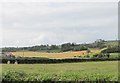
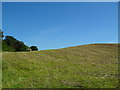
Croplands west of the Black Causeway Road
This is an area of good quality farmland.
Image: © Eric Jones
Taken: 20 Sep 2011
0.14 miles
2
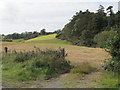
Margin between forest and cropland alongside the Black Causeway Road
The woodland occupies an area of forest and wetland extending northwards towards Castleward Bay.
Image: © Eric Jones
Taken: 20 Sep 2011
0.16 miles
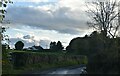
3
The Blackcauseway Road near Strangford
The Blackcauseway Road is a secondary road from Strangford to Downpatrick and Ardglass. This is the view towards the main Strangford-Downpatrick road.
Image: © Albert Bridge
Taken: 5 Dec 2006
0.16 miles
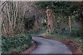
4
Strangford Upper Townland
This townland adjoins the village of Strangford. On the Black Causeway Road.
Image: © Dean Molyneaux
Taken: 13 Sep 2009
0.18 miles