IMAGES TAKEN NEAR TO
Mearne Road, DOWNPATRICK, BT30 7HZ
Introduction
This page details the photographs taken nearby to Mearne Road, BT30 7HZ by members of the Geograph project.
The Geograph project started in 2005 with the aim of publishing, organising and preserving representative images for every square kilometre of Great Britain, Ireland and the Isle of Man.

There are currently over 7.5m images from over14,400 individuals and you can help contribute to the project by visiting https://www.geograph.org.uk
Image Map
Images are licensed for reuse under creativecommons.org/licenses/by-sa/2.0
Notes
- Clicking on the map will re-center to the selected point.
- The higher the marker number, the further away the image location is from the centre of the postcode.
Image Listing (6 Images Found)
Images are licensed for reuse under creativecommons.org/licenses/by-sa/2.0
Image
Details
Distance
1
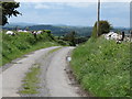
The crest of a hill on the Mearne Road
The road descends westwards towards the village of Saul.
Image: © Eric Jones
Taken: 7 Jun 2011
0.04 miles
2
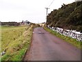
Mearne Road at Ballystokes
Leading east from Saul around the back of Slieve Patrick to Lough Money.
Townland of Ballystokes.
Image: © Dean Molyneaux
Taken: 7 Feb 2010
0.13 miles
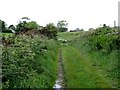
3
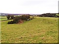
Ballystokes Townland
Along the Mearne Road, east of Saul village.
Image: © Dean Molyneaux
Taken: 7 Feb 2010
0.14 miles
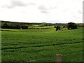
5
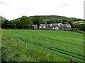
The hamlet of Ballystokes
The forested Slievenagriddle forms the background.
Image: © Eric Jones
Taken: 7 Jun 2011
0.21 miles
6
Approaching the hamlet of Ballystokes along St Patrick's Way
Image: © Eric Jones
Taken: 7 Jun 2011
0.24 miles