IMAGES TAKEN NEAR TO
Ardcuan Park, DOWNPATRICK, BT30 7HX
Introduction
This page details the photographs taken nearby to Ardcuan Park, BT30 7HX by members of the Geograph project.
The Geograph project started in 2005 with the aim of publishing, organising and preserving representative images for every square kilometre of Great Britain, Ireland and the Isle of Man.

There are currently over 7.5m images from over14,400 individuals and you can help contribute to the project by visiting https://www.geograph.org.uk
Image Map
Images are licensed for reuse under creativecommons.org/licenses/by-sa/2.0
Notes
- Clicking on the map will re-center to the selected point.
- The higher the marker number, the further away the image location is from the centre of the postcode.
Image Listing (12 Images Found)
Images are licensed for reuse under creativecommons.org/licenses/by-sa/2.0
Image
Details
Distance
1
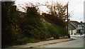
Old YHANI Youth Hostel at Raholp, County Down
The little cottage buried under the greenery was once a tiny youth hostel in Raholp village, Co Down, Northern Ireland, run by the Youth Hostel Association of Northern Ireland. It opened in 1937, but was curtailed at the outbreak of war. The smart cottage beyond it was the warden's house. The Grid Reference is checked against the NI 1" map of 1966.
Image: © John Martin
Taken: 24 Oct 2006
0.02 miles
2
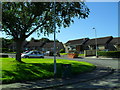
Ardcuan Park, Raholp
The only NIHE scheme in the village.
Image: © Dean Molyneaux
Taken: 13 Sep 2009
0.02 miles
3
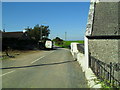
Ballintogher Road, Raholp
Leads between Raholp village and the Strangford Road.
Image: © Dean Molyneaux
Taken: 13 Sep 2009
0.03 miles
4

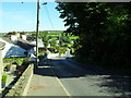
Linear settlement at Raholp
Raholp is very much a street village, with a number of farmhouses also sited on the village street.
Image: © Eric Jones
Taken: 7 Jun 2011
0.07 miles
5
Raholp village
A fine village in north Lecale.
Image: © Dean Molyneaux
Taken: 13 Sep 2009
0.08 miles
6
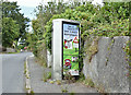
KX300 telephone box, Raholp (July 2017)
Image: © Albert Bridge
Taken: 29 Jul 2017
0.10 miles
7
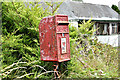
Postbox BT30 7JJ, Raholp (July 2017)
A very tatty post-mounted EIIR postbox (BT30 7JJ) beside the former “Slaney Inn” Image (background).
Image: © Albert Bridge
Taken: 29 Jul 2017
0.11 miles
8
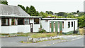
Former "Slaney Inn", Raholp (July 2017)
The remains of the former “Slaney Inn” at 62 St Patrick’s Road Image
Image: © Albert Bridge
Taken: 29 Jul 2017
0.13 miles
9
View west along St Patrick's Road at Raholp
Image: © Eric Jones
Taken: 28 Aug 2014
0.16 miles
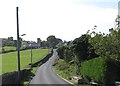
10

View West along St Patrick's Road at Raholp
The image was taken from the mouth of the Loughmoney Road.
Image: © Eric Jones
Taken: 7 Jun 2011
0.20 miles