IMAGES TAKEN NEAR TO
Elliotts Court, DOWNPATRICK, BT30 7HT
Introduction
This page details the photographs taken nearby to Elliotts Court, BT30 7HT by members of the Geograph project.
The Geograph project started in 2005 with the aim of publishing, organising and preserving representative images for every square kilometre of Great Britain, Ireland and the Isle of Man.

There are currently over 7.5m images from over14,400 individuals and you can help contribute to the project by visiting https://www.geograph.org.uk
Image Map
Images are licensed for reuse under creativecommons.org/licenses/by-sa/2.0
Notes
- Clicking on the map will re-center to the selected point.
- The higher the marker number, the further away the image location is from the centre of the postcode.
Image Listing (332 Images Found)
Images are licensed for reuse under creativecommons.org/licenses/by-sa/2.0
Image
Details
Distance
1
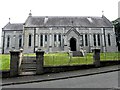
RC Church, Strangford
Pictured along Shore Road
Image: © Kenneth Allen
Taken: 18 Jul 2012
0.00 miles
2
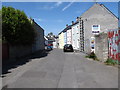
North-western end of Stella Maris Street, Portaferry
This leads to the village square.
Image: © Eric Jones
Taken: 21 May 2012
0.00 miles
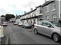
3
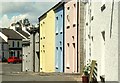
Stella Maris Street, Strangford
Stella Maris Street looking towards The Square. The grey building (middle left) is a former garage converted to a pharmacy. The brightly-coloured terrace has just been completed while the light grey building nearest the camera is a bit older. An attractive streetscape blending well.
Image: © Albert Bridge
Taken: 19 Jun 2008
0.01 miles
5
Castleward Road, Strangford
Heading WSW
Image: © Kenneth Allen
Taken: 18 Jul 2012
0.02 miles
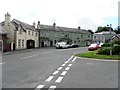
6
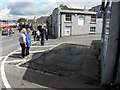
Weighbridge, Strangford
Pictured along Castleward Road
See close-up of inscription here Image]
Image: © Kenneth Allen
Taken: 18 Jul 2012
0.02 miles
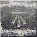
7
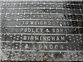
Inscription, Weighbridge, Strangford
Pictured here Image]
Image: © Kenneth Allen
Taken: 18 Jul 2012
0.02 miles
8
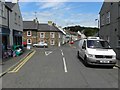
Shore Road, Strangford
Heading north-west towards Castleward Road
Image: © Kenneth Allen
Taken: 18 Jul 2012
0.02 miles
9
Bench mark, Strangford
Cut bench mark on the wall of a house in central Strangford.
The mark has been levelled to 5.79 metres above MSL.
Image: © Rossographer
Taken: 20 May 2017
0.02 miles
10

The Downpatrick bus, Strangford
Image: © Albert Bridge
Taken: 17 Sep 2009
0.02 miles