IMAGES TAKEN NEAR TO
Ferry Quarter Gardens, DOWNPATRICK, BT30 7GU
Introduction
This page details the photographs taken nearby to Ferry Quarter Gardens, BT30 7GU by members of the Geograph project.
The Geograph project started in 2005 with the aim of publishing, organising and preserving representative images for every square kilometre of Great Britain, Ireland and the Isle of Man.

There are currently over 7.5m images from over14,400 individuals and you can help contribute to the project by visiting https://www.geograph.org.uk
Image Map
Images are licensed for reuse under creativecommons.org/licenses/by-sa/2.0
Notes
- Clicking on the map will re-center to the selected point.
- The higher the marker number, the further away the image location is from the centre of the postcode.
Image Listing (310 Images Found)
Images are licensed for reuse under creativecommons.org/licenses/by-sa/2.0
Image
Details
Distance
1
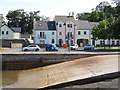
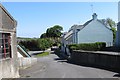
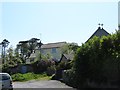
Houses in Stella Maris Street, Strangford
The slip way in the foreground is that of the dry dock.
Image: © Eric Jones
Taken: 10 Aug 2015
0.01 miles
2
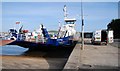
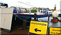
The Strangford Lough ferry (5)
The “Portaferry II” during her annual overhaul at Strangford.
Image: © Albert Bridge
Taken: 6 Nov 2007
0.02 miles
4
Modern terraced houses in Stella Maris Street, Strangford
Image: © Eric Jones
Taken: 20 Jul 2017
0.03 miles
5
The Strangford Lough ferry (19)
See Image The “missing” ramp undergoing overhaul in the car park.
Image: © Albert Bridge
Taken: 5 Dec 2009
0.03 miles
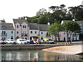
6
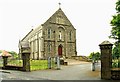
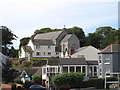
Star of the Sea church, Strangford
Roman Catholic church on the Shore Road – built in 1820 on a site donated by and at the expense of Lord Henry Fitzgerald.
Image: © Albert Bridge
Taken: 17 Jun 2009
0.03 miles
7
New Houses in Stella Maris Street, Strangford
Image: © Eric Jones
Taken: 21 May 2012
0.03 miles
8
The Inverbrena Community Centre, Stella Maris Street, Portaferry
http://www.inverbrena.co.uk/
Image: © Eric Jones
Taken: 21 May 2012
0.03 miles
9
The Catholic Presbytery and the rear of the Star of the Sea Chapel from Stella Maris Street
Image: © Eric Jones
Taken: 21 May 2012
0.04 miles
10
St Mary's Star of the Sea Catholic Chapel, Strangford
This church is part of a joint pastorate with St Malachy's Church, Kilclief. Both Strangford and Kilclief are predominantly Catholic and Nationalist communities. Some 83% of the combined population of 2350 are from this background. The land for the building of the chapel was granted by Lord Henry Fitzgerald in 1820. The present building dates from the 1930s after a fire had destroyed the earlier building.
Image: © Eric Jones
Taken: 20 Jul 2017
0.04 miles