IMAGES TAKEN NEAR TO
Ardglass Road, DOWNPATRICK, BT30 7ED
Introduction
This page details the photographs taken nearby to Ardglass Road, BT30 7ED by members of the Geograph project.
The Geograph project started in 2005 with the aim of publishing, organising and preserving representative images for every square kilometre of Great Britain, Ireland and the Isle of Man.

There are currently over 7.5m images from over14,400 individuals and you can help contribute to the project by visiting https://www.geograph.org.uk
Image Map
Images are licensed for reuse under creativecommons.org/licenses/by-sa/2.0
Notes
- Clicking on the map will re-center to the selected point.
- The higher the marker number, the further away the image location is from the centre of the postcode.
Image Listing (8 Images Found)
Images are licensed for reuse under creativecommons.org/licenses/by-sa/2.0
Image
Details
Distance
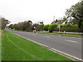
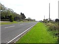
2
The Ardglass Road
This road links Downpatrick with the fishing port of Ardglass.
Image: © Eric Jones
Taken: 4 Oct 2011
0.04 miles
3
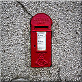
Postbox near Ardglass
Edward VII lamp box (BT30 29), now set into a wall on the Ardglass Road, around 1 mile NW of Ardglass. Very rare in Northern Ireland.
Image: © Rossographer
Taken: 24 Jul 2022
0.09 miles
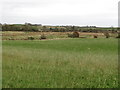
4
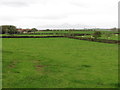
Farmland west of the Ardglass Road
The background is formed by the Mourne Mountains.
Image: © Eric Jones
Taken: 4 Oct 2011
0.11 miles
6
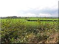
Strand Townland
Looking south-west from Ardglass Road
Image: © Kenneth Allen
Taken: 3 Oct 2011
0.21 miles
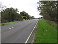
7
B1, Ardglass Road
Heading south-east at Strand
Image: © Kenneth Allen
Taken: 3 Oct 2011
0.21 miles
8
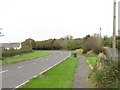
New and old sections of the Ardglass Road
Image: © Eric Jones
Taken: 4 Oct 2011
0.23 miles