IMAGES TAKEN NEAR TO
Ardglass Road, DOWNPATRICK, BT30 7EA
Introduction
This page details the photographs taken nearby to Ardglass Road, BT30 7EA by members of the Geograph project.
The Geograph project started in 2005 with the aim of publishing, organising and preserving representative images for every square kilometre of Great Britain, Ireland and the Isle of Man.

There are currently over 7.5m images from over14,400 individuals and you can help contribute to the project by visiting https://www.geograph.org.uk
Image Map
Images are licensed for reuse under creativecommons.org/licenses/by-sa/2.0
Notes
- Clicking on the map will re-center to the selected point.
- The higher the marker number, the further away the image location is from the centre of the postcode.
Image Listing (7 Images Found)
Images are licensed for reuse under creativecommons.org/licenses/by-sa/2.0
Image
Details
Distance
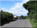
1
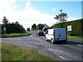
Molly Blayney's Corner at the junction of Ardglass Road and Ballee Road
The bus rapidly disappearing over the brow of the hill is the twice daily 16F Downpatrick to Ardglass direct service.
Image: © Eric Jones
Taken: 18 Aug 2014
0.02 miles
3
The B1 (Ardglass Road) at its junction with Ballyclander Road
The image was taken from Molly Blayney's Corner.
Image: © Eric Jones
Taken: 18 Aug 2014
0.07 miles
4
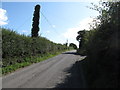
Ballee Road east of Molly Blayney's Corner
Image: © Eric Jones
Taken: 18 Aug 2014
0.11 miles
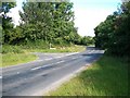
5
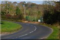
The Ardglass Road near Downpatrick
The Downpatrick – Ardglass road starts off twisting and turning and ends in a level straight. This is the view towards Downpatrick as it approaches Molly Blaney’s Corner near Ballee.
Image: © Albert Bridge
Taken: 6 Nov 2007
0.11 miles
6
Houses on the Ballee Road east of Molly Blayney's Corner
Image: © Eric Jones
Taken: 18 Aug 2014
0.13 miles
7
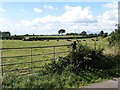
Farmland south of the Ballee Road
The mourne mountains can be seen in the background.
Image: © Eric Jones
Taken: 18 Aug 2014
0.15 miles