IMAGES TAKEN NEAR TO
Ballyculter Road, DOWNPATRICK, BT30 7BD
Introduction
This page details the photographs taken nearby to Ballyculter Road, BT30 7BD by members of the Geograph project.
The Geograph project started in 2005 with the aim of publishing, organising and preserving representative images for every square kilometre of Great Britain, Ireland and the Isle of Man.

There are currently over 7.5m images from over14,400 individuals and you can help contribute to the project by visiting https://www.geograph.org.uk
Image Map
Images are licensed for reuse under creativecommons.org/licenses/by-sa/2.0
Notes
- Clicking on the map will re-center to the selected point.
- The higher the marker number, the further away the image location is from the centre of the postcode.
Image Listing (13 Images Found)
Images are licensed for reuse under creativecommons.org/licenses/by-sa/2.0
Image
Details
Distance
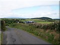
1
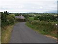
Bend in the Ballyculter Road above Ballyrenan
Image: © Eric Jones
Taken: 29 Jul 2011
0.01 miles
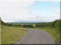
2
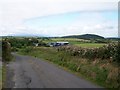
Ballyculter Road descending towards Ballyrenan Farm
The name Ballyrenan is derived from the Irish Baile Raghnaill meaning Reynold’s or Randal’s townland.
Image: © Eric Jones
Taken: 29 Jul 2011
0.01 miles
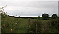
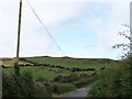
3
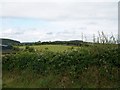
Pastureland at Ballyrenan Farm
The outbuildings of the farm can be seen at the extreme left of the image.
Image: © Eric Jones
Taken: 29 Jul 2011
0.09 miles
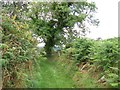
4
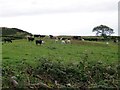
Grazing land near the Ballyculter Road end of St Patrick's green lane
Image: © Eric Jones
Taken: 29 Jul 2011
0.09 miles
5
Descending Ballyculter Road in the direction of Ballyrenan Crossroads
Ballyrenan Farm can be seen in the middle ground.
Image: © Eric Jones
Taken: 29 Jul 2011
0.10 miles
6
A bend in the Ballyculter Road near the southern end of St Patrick's Way
St Patrick's Way, a green lane, leads north-westwards towards Carronacaw. The mist capped Mourne Mountains form the background.
Image: © Eric Jones
Taken: 29 Jul 2011
0.11 miles
7
Undulating pasture land south of the Ballyculter Road
Image: © Eric Jones
Taken: 29 Jul 2011
0.12 miles
8
St Patrick's Way
St Patrick's Way, a green lane, leads north-westwards from Ballyculter Road towards Carronacaw.
Image: © Eric Jones
Taken: 29 Jul 2011
0.14 miles
9
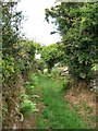
St Patrick's Way
This green lane links Ballyculter Road with the Carrownacow Road.
Image: © Eric Jones
Taken: 29 Jul 2011
0.17 miles
10
View west towards the Cross Shanenahannan Cairn from the Ballyculter Road
The cairn is located on the skyline.
Image: © Eric Jones
Taken: 29 Jul 2011
0.19 miles