IMAGES TAKEN NEAR TO
Vianstown Lodge, DOWNPATRICK, BT30 6XA
Introduction
This page details the photographs taken nearby to Vianstown Lodge, BT30 6XA by members of the Geograph project.
The Geograph project started in 2005 with the aim of publishing, organising and preserving representative images for every square kilometre of Great Britain, Ireland and the Isle of Man.

There are currently over 7.5m images from over14,400 individuals and you can help contribute to the project by visiting https://www.geograph.org.uk
Image Map
Images are licensed for reuse under creativecommons.org/licenses/by-sa/2.0
Notes
- Clicking on the map will re-center to the selected point.
- The higher the marker number, the further away the image location is from the centre of the postcode.
Image Listing (15 Images Found)
Images are licensed for reuse under creativecommons.org/licenses/by-sa/2.0
Image
Details
Distance
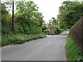
1
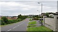
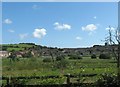
View north along Vianstown Road
The spire of St Patrick's Catholic Church can be seen in the background.
Image: © Eric Jones
Taken: 6 Jun 2011
0.10 miles
2
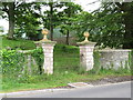
Ornamental park land gates below Bishop's Brae
Image: © Eric Jones
Taken: 6 Jun 2011
0.14 miles
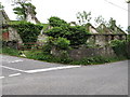
3
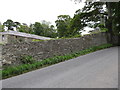
Estate wall and buildings on Bishop's Brae
Image: © Eric Jones
Taken: 6 Jun 2011
0.15 miles
4
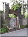
Crested arch at Bishop's Brae, Downpatrick
Image: © Eric Jones
Taken: 6 Jun 2011
0.15 miles
5
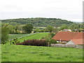
Part of the undulating race course at Downpatrick
Image: © Eric Jones
Taken: 6 Jun 2011
0.16 miles
6
Roofless cottages at the junction of Vianstown Road and Bishops Brae
These two roads on the southern outskirts of Downpatrick are equally narrow and busy.
Image: © Eric Jones
Taken: 6 Jun 2011
0.18 miles
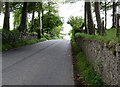
8
Vianstown Road at its junction with Bishop's Brae
Image: © Eric Jones
Taken: 6 Jun 2011
0.19 miles
9
Houses on Racecourse Road, Downpatrick
The image was taken from the A25 (Ballydugan Road). The spire of St Colmcille Church can be seen on the skyline (left).
Image
Image: © Eric Jones
Taken: 29 Jul 2011
0.20 miles
10
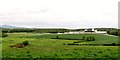
Agricultural land within the Down Race Course
Image: © Eric Jones
Taken: 6 Jun 2011
0.21 miles