IMAGES TAKEN NEAR TO
Spelga Close, DOWNPATRICK, BT30 6TT
Introduction
This page details the photographs taken nearby to Spelga Close, BT30 6TT by members of the Geograph project.
The Geograph project started in 2005 with the aim of publishing, organising and preserving representative images for every square kilometre of Great Britain, Ireland and the Isle of Man.

There are currently over 7.5m images from over14,400 individuals and you can help contribute to the project by visiting https://www.geograph.org.uk
Image Map
Images are licensed for reuse under creativecommons.org/licenses/by-sa/2.0
Notes
- Clicking on the map will re-center to the selected point.
- The higher the marker number, the further away the image location is from the centre of the postcode.
Image Listing (17 Images Found)
Images are licensed for reuse under creativecommons.org/licenses/by-sa/2.0
Image
Details
Distance
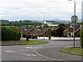
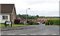
1
Houses on Racecourse Road, Downpatrick
The image was taken from the A25 (Ballydugan Road). The spire of St Colmcille Church can be seen on the skyline (left).
Image
Image: © Eric Jones
Taken: 29 Jul 2011
0.04 miles
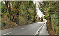
2
View north along Vianstown Road
The spire of St Patrick's Catholic Church can be seen in the background.
Image: © Eric Jones
Taken: 6 Jun 2011
0.09 miles
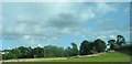
3
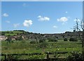
Part of the undulating race course at Downpatrick
Image: © Eric Jones
Taken: 6 Jun 2011
0.11 miles
4
The Grandstand at Downpatrick Race Course viewed from the southern entrance to Race Course Road
Image: © Eric Jones
Taken: 6 Jun 2011
0.14 miles
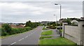
5
Race Course Road, Downpatrick
This estate is situated next to Downpatrick Race Course.
Image: © Eric Jones
Taken: 6 Jun 2011
0.14 miles
6
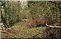
Old railway, Downpatrick (4 of 4)
See Image The view, towards Ardglass, along the course of the line. 62 years after closure nature has done its best to reclaim the works of man.
Image: © Albert Bridge
Taken: 22 Feb 2012
0.20 miles
7
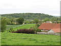
Farmland on the north side of Downpatrick Racecourse
Image: © Eric Jones
Taken: 20 Aug 2009
0.21 miles
8
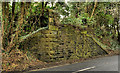
Old railway, Downpatrick (1 of 4)
The view, inward, of the remains of the bridge which carried the Ardglass Image branch across the Ballydugan Road. Continue to Image
Image: © Albert Bridge
Taken: 22 Feb 2012
0.21 miles
9
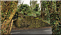
Old railway, Downpatrick (2 of 4)
See Image The remains of the parapet, from road level, on the Downpatrick side of the Ballydugan Road. Continue to Image
Image: © Albert Bridge
Taken: 22 Feb 2012
0.21 miles
10
Old railway, Downpatrick (3 of 4)
See Image The remains of the bridge (looking towards Downpatrick) from track level. Continue to Image
Image: © Albert Bridge
Taken: 22 Feb 2012
0.21 miles