IMAGES TAKEN NEAR TO
Mearne Road, DOWNPATRICK, BT30 6SW
Introduction
This page details the photographs taken nearby to Mearne Road, BT30 6SW by members of the Geograph project.
The Geograph project started in 2005 with the aim of publishing, organising and preserving representative images for every square kilometre of Great Britain, Ireland and the Isle of Man.

There are currently over 7.5m images from over14,400 individuals and you can help contribute to the project by visiting https://www.geograph.org.uk
Image Map
Images are licensed for reuse under creativecommons.org/licenses/by-sa/2.0
Notes
- Clicking on the map will re-center to the selected point.
- The higher the marker number, the further away the image location is from the centre of the postcode.
Image Listing (8 Images Found)
Images are licensed for reuse under creativecommons.org/licenses/by-sa/2.0
Image
Details
Distance
1
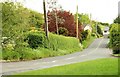
The Mearne Road near Downpatrick
The Mearne Road is a minor road running from the Downpatrick – Strangford Road to Saul.
Image: © Albert Bridge
Taken: 18 May 2009
0.13 miles
2
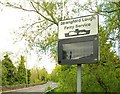
Ferry information sign near Downpatrick
The lower sign is used to advise of alterations to the Strangford Lough ferry service (delays, cancellations and additional sailings etc). At the corner of the Strangford Road (left) and the Mearne Road Image
Image: © Albert Bridge
Taken: 18 May 2009
0.21 miles
3
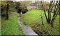
Stream near Downpatrick
A stream, rising nearby, flowing under the Strangford Road (background) into the Quoile (behind me).
Image: © Albert Bridge
Taken: 29 Oct 2010
0.22 miles
4
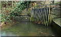
Culvert, Downpatrick
Image: © Albert Bridge
Taken: 9 Feb 2011
0.22 miles
5

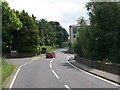
Crossroads near Downpatrick
The staggered crossroads on the Downpatrick - Strangford Road Image The Mearne Road Image is on the left and the Quoile Road Image on the right. The recently-built Quoile Quay apartments are at middle right.
Image: © Albert Bridge
Taken: 18 May 2009
0.23 miles
6

Old steps near Downpatrick
Steps, leading from the Strangford Road Image, to a short section of disused path to the main path at the Quoile Pondage Image
Image: © Albert Bridge
Taken: 18 May 2009
0.23 miles
7
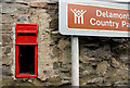
Disused letter box, Downpatrick
Doorless EIIR wall box, at the corner of the Strangford and Quoile Roads.
Image: © Albert Bridge
Taken: 9 Feb 2011
0.23 miles
8
A minor crossroads on the A25 (Strangford Road)
The junction on the left is with Mearne Road and that on the right with Quoile Road.
Image: © Eric Jones
Taken: 25 Jun 2013
0.24 miles