IMAGES TAKEN NEAR TO
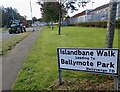
Islandbane Walk, DOWNPATRICK, BT30 6RN
Introduction
This page details the photographs taken nearby to Islandbane Walk, BT30 6RN by members of the Geograph project.
The Geograph project started in 2005 with the aim of publishing, organising and preserving representative images for every square kilometre of Great Britain, Ireland and the Isle of Man.

There are currently over 7.5m images from over14,400 individuals and you can help contribute to the project by visiting https://www.geograph.org.uk
Image Map
Images are licensed for reuse under creativecommons.org/licenses/by-sa/2.0
Notes
- Clicking on the map will re-center to the selected point.
- The higher the marker number, the further away the image location is from the centre of the postcode.
Image Listing (29 Images Found)
Images are licensed for reuse under creativecommons.org/licenses/by-sa/2.0
Image
Details
Distance
1
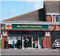
The Ballymote Post Office
This is situated in the Ballymote Shopping Centre. The PSNI presence is due to a Tiger Kidnapping incident earlier in the day.
http://www.newstin.co.uk/rel/uk/en-010-017507781
http://en.wikipedia.org/wiki/Tiger_kidnapping
Image: © Eric Jones
Taken: 20 Aug 2009
0.01 miles
2
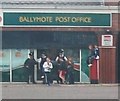
PSNI guard and a gang of inquisitive estate kids at Ballymote Post Office.
The policemen's presence at the scene of a Tiger kidnapping incident attracts a crowd of kids.
http://en.wikipedia.org/wiki/Tiger_kidnapping
Image: © Eric Jones
Taken: 20 Aug 2009
0.01 miles
3
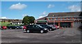
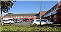
Car Park at the Ballymote Shopping Centre
The Model Farm Estate forms the background on the left.
Image: © Eric Jones
Taken: 20 Aug 2009
0.02 miles
4
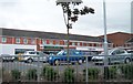
Ballymote Shopping Centre, Killough Road, Downpatrick
Image: © Eric Jones
Taken: 20 Jul 2011
0.04 miles
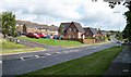
7
Suburban housing estates along Killough Road, Ballymote, Downpatrick
Image: © Eric Jones
Taken: 22 Jul 2013
0.06 miles
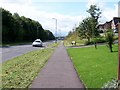
8
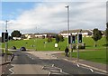
Pedestrian crossing on the Killough Road at Ballymote
Image: © Eric Jones
Taken: 22 Jul 2013
0.06 miles
9
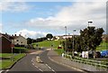
Flying Horse Road
This road links the Killough and Ardglass Roads on the eastern periphery of Downpatrick. The estate on the left is Struell Heights.
Image: © Eric Jones
Taken: 20 Aug 2009
0.06 miles
10
The Flying Horse Road near its junction with the Killough Road
Image: © Eric Jones
Taken: 20 Aug 2009
0.06 miles