IMAGES TAKEN NEAR TO
Saul Road, DOWNPATRICK, BT30 6NN
Introduction
This page details the photographs taken nearby to Saul Road, BT30 6NN by members of the Geograph project.
The Geograph project started in 2005 with the aim of publishing, organising and preserving representative images for every square kilometre of Great Britain, Ireland and the Isle of Man.

There are currently over 7.5m images from over14,400 individuals and you can help contribute to the project by visiting https://www.geograph.org.uk
Image Map
Images are licensed for reuse under creativecommons.org/licenses/by-sa/2.0
Notes
- Clicking on the map will re-center to the selected point.
- The higher the marker number, the further away the image location is from the centre of the postcode.
Image Listing (5 Images Found)
Images are licensed for reuse under creativecommons.org/licenses/by-sa/2.0
Image
Details
Distance
1

Rathkeltair Road, Downpatrick
This leads from the Saul Road to the Strangford Road - past St. Brigid's chapel and Primary School (to left).
Image: © Dean Molyneaux
Taken: 31 Aug 2009
0.12 miles
2
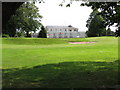
Clubhouse, Downpatrick Golf Club
In wooded grounds off the Saul Road.
Image: © Dean Molyneaux
Taken: 31 Aug 2009
0.15 miles
3
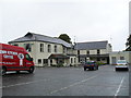
Restaurant and Bar at Downpatrick Golf Course
Image: © Eric Jones
Taken: 7 Jun 2011
0.16 miles
4
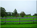
Downpatrick Golf Club
An 18 hole Par 69 course off the Saul Road - designed in 1930.
Image: © Dean Molyneaux
Taken: 31 Aug 2009
0.18 miles
5
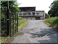
Derelict Meat Products Factory on Saul Road
Image: © Eric Jones
Taken: 7 Jun 2011
0.24 miles