IMAGES TAKEN NEAR TO
Market Street, DOWNPATRICK, BT30 6LZ
Introduction
This page details the photographs taken nearby to Market Street, BT30 6LZ by members of the Geograph project.
The Geograph project started in 2005 with the aim of publishing, organising and preserving representative images for every square kilometre of Great Britain, Ireland and the Isle of Man.

There are currently over 7.5m images from over14,400 individuals and you can help contribute to the project by visiting https://www.geograph.org.uk
Image Map
Images are licensed for reuse under creativecommons.org/licenses/by-sa/2.0
Notes
- Clicking on the map will re-center to the selected point.
- The higher the marker number, the further away the image location is from the centre of the postcode.
Image Listing (419 Images Found)
Images are licensed for reuse under creativecommons.org/licenses/by-sa/2.0
Image
Details
Distance
1
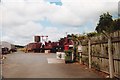
Downpatrick Railway Museum
The Downpatrick & County Down Railway is Northern Ireland's only heritage steam railway. The original station in Market Street was demolished in 1972 to make way for a supermarket. It had served as a bus station from the railway's closure in 1950 until 1972. Downpatrick gasworks was located just across the street from the railway station. When it was closed and demolished to make way for a new college, the manager's house, a listed 19th century building, had to be retained. The Railway came to an arrangement whereby the building was dismantled, moved across the road to the railway site and a grant obtained for its reconstruction as the station building. Unfortunately the railway wasn't open on the day of my visit and I was only able to take this rather poor shot through some stout steel gates.
Image: © Ron Strutt
Taken: 12 Jul 2001
0.01 miles
2
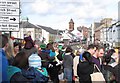
St Patrick Day's Crowd in Market Street, Downpatrick
Image: © Eric Jones
Taken: 17 Mar 2012
0.01 miles
3
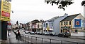
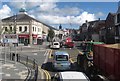
Downpatrick's Market Street
This is the main shopping street of the town.
Image: © Eric Jones
Taken: 20 Aug 2009
0.01 miles
4
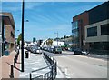
View northwards along Market Street, Downpatrick
This image was taken from the vehicle entrance to the Ulsterbus Depot. The brick and glass building on the right is the SELEB (South Eastern Education and Library Board) Regional College.
Image: © Eric Jones
Taken: 4 Jul 2011
0.02 miles
5
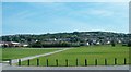
Playing fields at the Downpatrick Sports and Leisure Centre
These are located on the east side of Ballydugan Road.
Image: © Eric Jones
Taken: 4 Jul 2011
0.02 miles
6
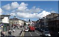
Heavy traffic in downtown Downpatrick
Situated in a rich farming area, Downpatrick's narrow streets are often clogged by agricultural traffic.
Image: © Eric Jones
Taken: 30 Aug 2017
0.02 miles
7

Lidl (Northern Ireland) Store, Market Street, Downpatrick
Image: © Eric Jones
Taken: 2 Aug 2013
0.03 miles
8

Downpatrick - View from St Patrick Centre toward Market Street (A25)
View is to southeast from entrance to Saint Patrick Centre.
Image: © Suzanne Mischyshyn
Taken: 22 Sep 2013
0.04 miles
9

Downpatrick - Market Street (A25) View to Northeast
View is from an unnamed short street between St Patrick Centre and Market Street (A25) at town centre.
Image: © Suzanne Mischyshyn
Taken: 22 Sep 2013
0.04 miles
10
Market Street, Downpatrick
This is the CBD of the cathedral town of Downpatrick. Situated in a rich farming area, its narrow streets are often clogged by agricultural traffic.
Image: © Eric Jones
Taken: 30 Aug 2017
0.05 miles