IMAGES TAKEN NEAR TO
St. Dillons Avenue, DOWNPATRICK, BT30 6HZ
Introduction
This page details the photographs taken nearby to St. Dillons Avenue, BT30 6HZ by members of the Geograph project.
The Geograph project started in 2005 with the aim of publishing, organising and preserving representative images for every square kilometre of Great Britain, Ireland and the Isle of Man.

There are currently over 7.5m images from over14,400 individuals and you can help contribute to the project by visiting https://www.geograph.org.uk
Image Map
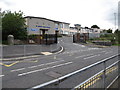
Images are licensed for reuse under creativecommons.org/licenses/by-sa/2.0
Notes
- Clicking on the map will re-center to the selected point.
- The higher the marker number, the further away the image location is from the centre of the postcode.
Image Listing (92 Images Found)
Images are licensed for reuse under creativecommons.org/licenses/by-sa/2.0
Image
Details
Distance
1
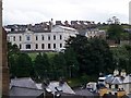
The now disused Downpatrick Hospital from St Patrick's Church
Image: © Eric Jones
Taken: 20 Aug 2009
0.07 miles
2
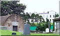
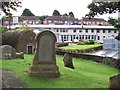
Downpatrick Hospital from the graveyard of the Non-Subscribing Presbyterian Church in Stream Street
This hospital is being replaced by a £64 million pound state of the art hospital built on the Struel Wells Road.
Image: © Eric Jones
Taken: 20 Aug 2009
0.10 miles
3
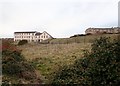
The derelict "old" Downe Hospital
The old infirmary was more accessible from the town than the new one which is located on the urban fringe.
Image: © Eric Jones
Taken: 21 Mar 2018
0.11 miles
4
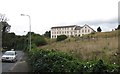
The Derelict Old Downe Hospital viewed from the Killough Road
Image: © Eric Jones
Taken: 18 Aug 2014
0.12 miles
5
St John's House Residential Care Home, Pound Street
This home caters for the frail elderly and for elderly persons with Dementia. It is located in Pound Lane, next to the Downe Hospital. The image was taken from the First Non-Subscribing Presbyterian Church's graveyard in Stream Street.
Image: © Eric Jones
Taken: 20 Aug 2009
0.13 miles
6
The old Down Hospital from St Patrick's Avenue
This hospital has now been replaced by the new Downe Hospital in Struell Wells Road
Image: © Eric Jones
Taken: 6 Jun 2011
0.13 miles
7
St Mary's High School, Ardglass Road, Downpatrick
This is a Catholic ethos community state school. It was established by the Sisters of Mercy as St Mary's Girls' Intermediate School in 1957 and in 1960 a grammar stream was added. Its name was then changed to St Mary's High School.
Image: © Eric Jones
Taken: 21 Mar 2018
0.14 miles
8
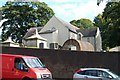
Downpatrick's First Non-Subscribing Presbyterian Church from Stream Street
Image: © Eric Jones
Taken: 20 Aug 2009
0.14 miles
9
St Mary's High School, Ardglass Road
This is a Catholic ethos community state school. It was established by the Sisters of Mercy as St Mary's Girls' Intermediate School in 1957 and in 1960 a grammar stream was added. Its name was then changed to St Mary's High School.
Image: © Eric Jones
Taken: 18 Aug 2014
0.14 miles
10
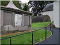
Large tombs in the churchyard of Downpatrick's First Presbyterian Church
Image: © Eric Jones
Taken: 20 Aug 2009
0.14 miles