IMAGES TAKEN NEAR TO
Drumcloon Walk, DOWNPATRICK, BT30 6HF
Introduction
This page details the photographs taken nearby to Drumcloon Walk, BT30 6HF by members of the Geograph project.
The Geograph project started in 2005 with the aim of publishing, organising and preserving representative images for every square kilometre of Great Britain, Ireland and the Isle of Man.

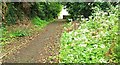
There are currently over 7.5m images from over14,400 individuals and you can help contribute to the project by visiting https://www.geograph.org.uk
Image Map
Images are licensed for reuse under creativecommons.org/licenses/by-sa/2.0
Notes
- Clicking on the map will re-center to the selected point.
- The higher the marker number, the further away the image location is from the centre of the postcode.
Image Listing (54 Images Found)
Images are licensed for reuse under creativecommons.org/licenses/by-sa/2.0
Image
Details
Distance
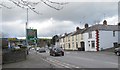
1
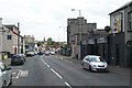
View south along Church Street, Downpatrick
Image: © Eric Jones
Taken: 25 Jun 2013
0.09 miles
2
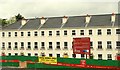
Quoile Crescent, Downpatrick (2)
See Image More than two years later, unfinished and boarded up, the buildings are offered for sale. The agents’ website describes then as “Attractive development requiring property and site completion works and comprising a mixture of 3 storey, 3 and 4 bed terraced townhouses and 3 bed semis. Offered for sale as one lot due to outstanding site works, however vendor may consider sale in parts dependent on individual proposals.”. This photograph appears as a matter of record only. I have no connection with any of the parties involved in the sale.
Image: © Albert Bridge
Taken: 12 Jul 2011
0.10 miles
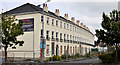
4
Quoile Crescent, Downpatrick (1)
Part of a new development, off Church Street, of town houses and semis.
Image shows the buildings, unfinished and boarded up, in July 2011.
Image: © Albert Bridge
Taken: 6 May 2009
0.12 miles
5
Breens Lane, Downpatrick
A short path running towards New Bridge Street (background).
Image: © Albert Bridge
Taken: 6 May 2009
0.13 miles
6
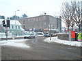
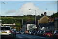
Winter scene on Church Street, Downpatrick
Cars trundle along Church Street, at its junction with Saul Way, as the icy roads slow down all road traffic. The bus in the picture is the 14.30 Ulsterbus service 15 from Belfast Europa to Downpatrick, running some twenty minutes late - no doubt a consequence of the treacherous condition of the A7 between Saintfield and Downpatrick.
Image: © Dean Molyneaux
Taken: 21 Dec 2010
0.13 miles
7
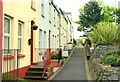
New Bridge Street, Downpatrick
Part of a terrace of modern houses opposite the Belfast Road.
Image: © Albert Bridge
Taken: 6 May 2009
0.13 miles
8
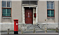
Pillar box, Downpatrick
EIIR pillar box, outside the telephone exchange, in Church Street.
Image: © Albert Bridge
Taken: 12 Jul 2011
0.13 miles
9
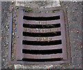
Bo-Ness grating cover, Downpatrick
A well-preserved Bo-Ness Iron Co Ltd grating cover
http://www.geograph.org.uk/search.php?i=23070195 in the footpath in Church Street.
Image: © Albert Bridge
Taken: 12 Jul 2011
0.14 miles
10
The northern end of Church Street, Downpatrick
Image: © Eric Jones
Taken: 4 Mar 2014
0.14 miles