IMAGES TAKEN NEAR TO
Tullywest Road, CRUMLIN, BT29 4SP

Introduction

This page details the photographs taken nearby to Tullywest Road, BT29 4SP by members of the Geograph project.

The Geograph project started in 2005 with the aim of publishing, organising and preserving representative images for every square kilometre of Great Britain, Ireland and the Isle of Man.

There are currently over 7.5m images from over14,400 individuals and you can help contribute to the project by visiting https://www.geograph.org.uk

Image Map


Images are licensed for reuse under creativecommons.org/licenses/by-sa/2.0
Notes
  • Clicking on the map will re-center to the selected point.
  • The higher the marker number, the further away the image location is from the centre of the postcode.

Image Listing (6 Images Found)

Images are licensed for reuse under creativecommons.org/licenses/by-sa/2.0
Image
Details
Distance
1
Tullywest Road
An attractive avenue of trees - and a telegraph pole - on the Tullywest Road near Killead.
Image: © Robert Ashby Taken: 10 Jul 2013
0.02 miles
2
Hillside near Tully
Looking SW from the A26 near the NE corner of the square
Image: © Chris Shaw Taken: 8 Feb 2006
0.19 miles
3
Killead Triangulation Pillar
Killead trig pillar, located in Tully townland between Nutt's Corner and Belfast International Airport at Aldergrove. The pillar sits at approx. 140m above sea level in farmland accessed from Tullywest Road - a covered reservoir is sited close by and there is an access track from the road. The pillar, in excellent condition but leaning at a slight angle, has been sited upon a small mound (possibly a tumulus or medieval motte - see below) and is enclosed by a fence. Good views are possible to the north-east towards the hamlet of Killead and beyond to Antrim. See also Image, Image and Image The Northern Ireland Sites and Monuments Record at http://apps.ehsni.gov.uk/ambit/Details.aspx?MonID=4082 gives the following information on the mound: "Just W of the summit of a substantial hill with extensive views. This is a small earthen mound on which is sited an OS triangulation pillar. There is no visible indication of an encircling ditch. The mound is 3.2m high & the summit is 4.2m across N-S x 5.5m E-W, while the base is 17m N-S x 16m E-W. The site is small & is probably a motte. It is not too badly damaged by the pillar."
Image: © Rossographer Taken: 1 Dec 2012
0.20 miles
4
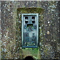
Flush Bracket, Killead Triangulation Pillar
Flush Bracket Bench Mark on Killead trig pillar Image The number on the bracket is OSNIBM 2095. The mark has not been levelled, although the pillar sits at about 140m above sea level.
Image: © Rossographer Taken: 1 Dec 2012
0.20 miles
5
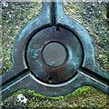
Spider, Killead Triangulation Pillar
Spider on the top of Killead trig pillar Image Note that it is marked "ORDNANCE SURVEY TRIANGULATION STATION".
Image: © Rossographer Taken: 1 Dec 2012
0.20 miles
6
Killead Triangulation Pillar
Killead trig pillar, located in Tully townland between Nutt's Corner and Belfast International Airport at Aldergrove. The pillar sits at approx. 140m above sea level in farmland accessed from Tullywest Road - a covered reservoir is sited close by and there is an access track from the road. The pillar, in excellent condition but leaning at a slight angle, has been sited upon a small mound (possibly a tumulus or medieval motte - see below) and is enclosed by a fence. This is a view of the field with the pillar located on the left atop the mound. Good views are possible to the north-east towards the hamlet of Killead and beyond to Antrim. See also Image The Northern Ireland Sites and Monuments Record at http://apps.ehsni.gov.uk/ambit/Details.aspx?MonID=4082 gives the following information on the mound: "Just W of the summit of a substantial hill with extensive views. This is a small earthen mound on which is sited an OS triangulation pillar. There is no visible indication of an encircling ditch. The mound is 3.2m high & the summit is 4.2m across N-S x 5.5m E-W, while the base is 17m N-S x 16m E-W. The site is small & is probably a motte. It is not too badly damaged by the pillar."
Image: © Rossographer Taken: 1 Dec 2012
0.21 miles