IMAGES TAKEN NEAR TO
Nutts Corner Road, CRUMLIN, BT29 4SH
Introduction
This page details the photographs taken nearby to Nutts Corner Road, BT29 4SH by members of the Geograph project.
The Geograph project started in 2005 with the aim of publishing, organising and preserving representative images for every square kilometre of Great Britain, Ireland and the Isle of Man.

There are currently over 7.5m images from over14,400 individuals and you can help contribute to the project by visiting https://www.geograph.org.uk
Image Map
Images are licensed for reuse under creativecommons.org/licenses/by-sa/2.0
Notes
- Clicking on the map will re-center to the selected point.
- The higher the marker number, the further away the image location is from the centre of the postcode.
Image Listing (2 Images Found)
Images are licensed for reuse under creativecommons.org/licenses/by-sa/2.0
Image
Details
Distance
1
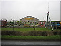
Erwin's
Agricultural Machinery Suppliers beside the A52.
Image: © Brian Shaw
Taken: 31 Jan 2006
0.18 miles
2
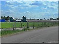
Former Nutt's Corner airfield
The Nutt's Corner airfield was where the Province's first London air service started in 1934. It became an RAF base during World War II and reverted to a civil airport again in 1946. By the end of the 1950's it had become unsuitable for modern aircraft and operations ceased. Nowadays it is the site of a motor-racing circuit though local complaints about noise restricted its use, a Sunday market, the Ulster Karting Club, a model aircraft club and this industrial site, which to me looks like a battery egg producing facility though I am open to correction on this.
Image: © Robert Ashby
Taken: 5 Jun 2013
0.23 miles