IMAGES TAKEN NEAR TO
Largy Road, CRUMLIN, BT29 4RS
Introduction
This page details the photographs taken nearby to Largy Road, BT29 4RS by members of the Geograph project.
The Geograph project started in 2005 with the aim of publishing, organising and preserving representative images for every square kilometre of Great Britain, Ireland and the Isle of Man.

There are currently over 7.5m images from over14,400 individuals and you can help contribute to the project by visiting https://www.geograph.org.uk
Image Map
Images are licensed for reuse under creativecommons.org/licenses/by-sa/2.0
Notes
- Clicking on the map will re-center to the selected point.
- The higher the marker number, the further away the image location is from the centre of the postcode.
Image Listing (7 Images Found)
Images are licensed for reuse under creativecommons.org/licenses/by-sa/2.0
Image
Details
Distance
1
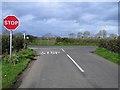
Bay Road
Looking at the junction with Largy Road
Image: © Kenneth Allen
Taken: 9 Apr 2008
0.08 miles
2
Ballymacmary Townland
Off the Largy Road, Crumlin.
Image: © Dean Molyneaux
Taken: 11 Apr 2010
0.09 miles
3

Pre-Worboys signage, Ballymacmary
An old-timer on the Largy Road (Crumlin) in the townland of Ballymacmary.
Image: © Dean Molyneaux
Taken: 11 Apr 2010
0.11 miles
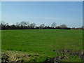
4

Bay Road, Ballymacmary
To the west of Crumlin in the townland of Ballymacmary.
Image: © Dean Molyneaux
Taken: 11 Apr 2010
0.11 miles
5
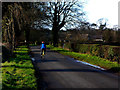
On the Loughshore Trail
A cyclist on Bay Road, part of the National Cycle Network's Route 94, The Loughshore Trail, a 113 mile cycle route round Lough Neagh, mostly on quiet minor roads with a few short off-road sections.
Image: © Robert Ashby
Taken: 23 Jan 2005
0.12 miles
6
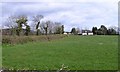
Moore View
Looking north from Largy Road
Image: © Kenneth Allen
Taken: 9 Apr 2008
0.12 miles
7
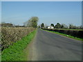
Largy Road at Ballymacmary
The Largy Road is the traditional continuation of the Nutts Corner Road (from Belfast) - running quite a straight course west towards Langford Lodge airfield and the shores of Lough Neagh.
Townland of Ballymacmary.
Image: © Dean Molyneaux
Taken: 11 Apr 2010
0.13 miles