IMAGES TAKEN NEAR TO
Loughview Road, CRUMLIN, BT29 4RF
Introduction
This page details the photographs taken nearby to Loughview Road, BT29 4RF by members of the Geograph project.
The Geograph project started in 2005 with the aim of publishing, organising and preserving representative images for every square kilometre of Great Britain, Ireland and the Isle of Man.

There are currently over 7.5m images from over14,400 individuals and you can help contribute to the project by visiting https://www.geograph.org.uk
Image Map
Images are licensed for reuse under creativecommons.org/licenses/by-sa/2.0
Notes
- Clicking on the map will re-center to the selected point.
- The higher the marker number, the further away the image location is from the centre of the postcode.
Image Listing (2 Images Found)
Images are licensed for reuse under creativecommons.org/licenses/by-sa/2.0
Image
Details
Distance
1
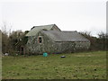
Outbuildings
They seem substantially built.
Image: © Brian Shaw
Taken: 23 Feb 2006
0.18 miles
2
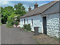
Cottage, Loughview Rd
A traditional whitewashed cottage on the Loughview Road. Originally it would have had a thatched roof but like many of these attractive buildings the thatch has been replaced by less charming but more functional and safer corrugated iron. Less of a fire hazard. That apart, the wheelie bin tethered to the door doesn't do much for the picture
Image: © Robert Ashby
Taken: 9 Jun 2013
0.20 miles