IMAGES TAKEN NEAR TO
The Diamond Road, CRUMLIN, BT29 4QY
Introduction
This page details the photographs taken nearby to The Diamond Road, BT29 4QY by members of the Geograph project.
The Geograph project started in 2005 with the aim of publishing, organising and preserving representative images for every square kilometre of Great Britain, Ireland and the Isle of Man.

There are currently over 7.5m images from over14,400 individuals and you can help contribute to the project by visiting https://www.geograph.org.uk
Image Map
Images are licensed for reuse under creativecommons.org/licenses/by-sa/2.0
Notes
- Clicking on the map will re-center to the selected point.
- The higher the marker number, the further away the image location is from the centre of the postcode.
Image Listing (4 Images Found)
Images are licensed for reuse under creativecommons.org/licenses/by-sa/2.0
Image
Details
Distance
1
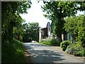
The Diamond Road
Not sure what this substantial and modern-looking structure is tucked away beside the junction of the Loughshore Road and The Diamond Road close to Lough Neagh. There are no name plates or identifying information to be seen and no label on the Google satellite image though the aerial picture shows a well-filled carpark. Perhaps someone can enlighten me.
Image: © Robert Ashby
Taken: 9 Jun 2013
0.02 miles
2
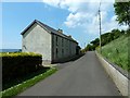
Loughview Road
A quite long house on the Loughview Road beside Lough Neagh. This quiet road is part of the National Cycle Network's Loughshore Trail (Route 94) which circles Lough Neagh for over 100 miles largely on roads like this.
Image: © Robert Ashby
Taken: 9 Jun 2013
0.05 miles
3
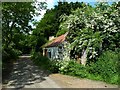
Derelict cottage
An abandoned cottage almost smothered in hawthorn bushes at the end of the Loughview Rd just past the junction with The Diamond Road.
Image: © Robert Ashby
Taken: 9 Jun 2013
0.11 miles
4
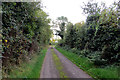
Loughview Road
Lough Neagh is just yards away behind the shrubbery to the right. Not much of a view though at this point. Looking south.
Image: © Robert Ashby
Taken: 14 Oct 2015
0.22 miles