IMAGES TAKEN NEAR TO
Ballyvannon Road, CRUMLIN, BT29 4QJ
Introduction
This page details the photographs taken nearby to Ballyvannon Road, BT29 4QJ by members of the Geograph project.
The Geograph project started in 2005 with the aim of publishing, organising and preserving representative images for every square kilometre of Great Britain, Ireland and the Isle of Man.

There are currently over 7.5m images from over14,400 individuals and you can help contribute to the project by visiting https://www.geograph.org.uk
Image Map
Images are licensed for reuse under creativecommons.org/licenses/by-sa/2.0
Notes
- Clicking on the map will re-center to the selected point.
- The higher the marker number, the further away the image location is from the centre of the postcode.
Image Listing (4 Images Found)
Images are licensed for reuse under creativecommons.org/licenses/by-sa/2.0
Image
Details
Distance
2
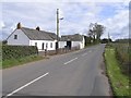
Ballyvollen Road
Heading north-east towards Ballyvollen
Image: © Kenneth Allen
Taken: 9 Apr 2008
0.15 miles
3
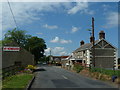
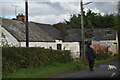
Ballyvannon Road
The little collection of houses on the Ballyvannon Rd. There has been an ongoing protest for several years about the building of an incinerator in the area.
Image: © Robert Ashby
Taken: 5 Jun 2013
0.16 miles
4
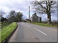
Ballyvollen Road
Looking south-west towards Ballyvanen
Image: © Kenneth Allen
Taken: 9 Apr 2008
0.22 miles