IMAGES TAKEN NEAR TO
Aghadolgan Road, CRUMLIN, BT29 4ND
Introduction
This page details the photographs taken nearby to Aghadolgan Road, BT29 4ND by members of the Geograph project.
The Geograph project started in 2005 with the aim of publishing, organising and preserving representative images for every square kilometre of Great Britain, Ireland and the Isle of Man.

There are currently over 7.5m images from over14,400 individuals and you can help contribute to the project by visiting https://www.geograph.org.uk
Image Map
Images are licensed for reuse under creativecommons.org/licenses/by-sa/2.0
Notes
- Clicking on the map will re-center to the selected point.
- The higher the marker number, the further away the image location is from the centre of the postcode.
Image Listing (3 Images Found)
Images are licensed for reuse under creativecommons.org/licenses/by-sa/2.0
Image
Details
Distance
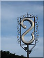
1
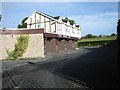
The Silver Eel
A pub on the road between Aghalee and Crumlin with a huge inn-sign.
Image: © Brian Shaw
Taken: 20 Oct 2005
0.07 miles
3
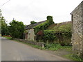
Nature reclaims its territory
A long-abandoned farmhouse on the Chapel Road, just off the Lurgan Road close to the Silver Eel roadhouse, is slowly swallowed up by vegetation.
Image: © Robert Ashby
Taken: 22 Sep 2013
0.20 miles