IMAGES TAKEN NEAR TO
Dundrod Road, CRUMLIN, BT29 4JN
Introduction
This page details the photographs taken nearby to Dundrod Road, BT29 4JN by members of the Geograph project.
The Geograph project started in 2005 with the aim of publishing, organising and preserving representative images for every square kilometre of Great Britain, Ireland and the Isle of Man.

There are currently over 7.5m images from over14,400 individuals and you can help contribute to the project by visiting https://www.geograph.org.uk
Image Map
Images are licensed for reuse under creativecommons.org/licenses/by-sa/2.0
Notes
- Clicking on the map will re-center to the selected point.
- The higher the marker number, the further away the image location is from the centre of the postcode.
Image Listing (3 Images Found)
Images are licensed for reuse under creativecommons.org/licenses/by-sa/2.0
Image
Details
Distance
1
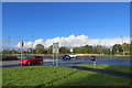
At The Crossroads
Where the Dundrod, Quarterlands, Leathemstown and Carnaghliss Roads meet.
Image: © Robert Ashby
Taken: 3 Nov 2013
0.08 miles
2
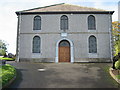
Dundrod Presbyterian Church
This "Presbyterian Meeting House" was built in 1827, as stated on the stone above the door.
Image: © Brian Shaw
Taken: 20 Oct 2005
0.17 miles
3
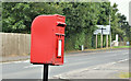
Postbox BT29 88, Dundrod village (August 2016)
Post-mounted EIIR postbox (BT29 88), on the Leathemstown Road, at Dundrod village.
Image: © Albert Bridge
Taken: 18 Aug 2016
0.17 miles