IMAGES TAKEN NEAR TO
St. James Meadow, CRUMLIN, BT29 4GU
Introduction
This page details the photographs taken nearby to St. James Meadow, BT29 4GU by members of the Geograph project.
The Geograph project started in 2005 with the aim of publishing, organising and preserving representative images for every square kilometre of Great Britain, Ireland and the Isle of Man.

There are currently over 7.5m images from over14,400 individuals and you can help contribute to the project by visiting https://www.geograph.org.uk
Image Map
Images are licensed for reuse under creativecommons.org/licenses/by-sa/2.0
Notes
- Clicking on the map will re-center to the selected point.
- The higher the marker number, the further away the image location is from the centre of the postcode.
Image Listing (4 Images Found)
Images are licensed for reuse under creativecommons.org/licenses/by-sa/2.0
Image
Details
Distance
1
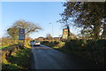
Watch your speed!
Speed limit signs approaching Crumlin along the narrow Cidercourt Road.
Image: © Robert Ashby
Taken: 4 Dec 2013
0.11 miles
3
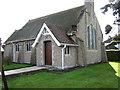
St John's Crumlin
This little Church of Ireland Church was built in 1905. Sorry about chopping the bell tower, but I was facing the sun, as can be seen from the shadow!
Image: © Brian Shaw
Taken: 20 Oct 2005
0.21 miles