IMAGES TAKEN NEAR TO
Killead Road, CRUMLIN, BT29 4EN
Introduction
This page details the photographs taken nearby to Killead Road, BT29 4EN by members of the Geograph project.
The Geograph project started in 2005 with the aim of publishing, organising and preserving representative images for every square kilometre of Great Britain, Ireland and the Isle of Man.

There are currently over 7.5m images from over14,400 individuals and you can help contribute to the project by visiting https://www.geograph.org.uk
Image Map
Images are licensed for reuse under creativecommons.org/licenses/by-sa/2.0
Notes
- Clicking on the map will re-center to the selected point.
- The higher the marker number, the further away the image location is from the centre of the postcode.
Image Listing (21 Images Found)
Images are licensed for reuse under creativecommons.org/licenses/by-sa/2.0
Image
Details
Distance
1
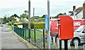
Postbox BT29 30, Killead (September 2017)
Post-mounted EIIR postbox, at Grove View, on the Killead Road. Previously a wall box opposite the Presbyterian church Image
Image: © Albert Bridge
Taken: 16 Sep 2017
0.07 miles
2
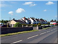
Killead Road
A neat row of houses at the end of the Killead Road
Image: © Robert Ashby
Taken: 5 Jun 2013
0.09 miles
3

White butterfly, Killead (September 2016)
A butterfly (possibly a small white http://www.irishbutterflies.com/small_white_butterfly_of_ireland.html?photo=1) on the hedge along Drennan’s Road Image
Image: © Albert Bridge
Taken: 5 Sep 2016
0.13 miles
4
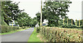
Drennan's Road, Killead (July 2016)
A minor road, through flat countryside, running south east off the Ballyrobin Road Image It passes close to the north eastern end of runway 25 at Belfast International (Aldergrove) Airport – the landing lights are the yellow poles at middle right. This view is from close to Killead Presbyterian church Image
Image: © Albert Bridge
Taken: 12 Jul 2016
0.14 miles
5
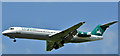
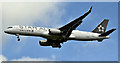
YR-FZA, Aldergrove - July 2017(2)
Carpatair Fokker F100 (YR-FZA) http://www.geograph.org.uk/search.php?i=74029611 returning with a Royal Caribbean fly-cruise (CityJet flight number) flight from Barcelona http://www.geograph.org.uk/search.php?i=73461799. Photographed from Drennan’s Road Image
Image: © Albert Bridge
Taken: 16 Jul 2017
0.19 miles
6
Direction signs, Killead (August 2016)
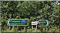
Direction signs, opposite the Carmavy Road Image, on the Tully Road Image – a road connecting the south and west to the north and north west.
Image: © Albert Bridge
Taken: 27 Aug 2016
0.21 miles
7
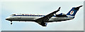
N14120, Aldergrove (July 2016)
United Airlines https://en.wikipedia.org/wiki/United_Airlines Star Alliance-liveried Boeing 757 arriving from Newark (New York) https://en.wikipedia.org/wiki/Newark_Liberty_International_Airport. Photographed from Drennan’s Road Image
Image: © Albert Bridge
Taken: 14 Jul 2016
0.22 miles
8
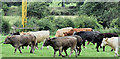
Cattle, Killead (August 2016)
Cattle in a field on the north eastern side of Drennan’s Road Image The airport landing lights Image are in the background.
Image: © Albert Bridge
Taken: 12 Aug 2016
0.23 miles
9
EW-276PJ, Aldergrove (March 2019)
Belavaia Bombardier CRJ-200ER (EW-276PJ), on final approach, with a Belarus football charter from Rotterdam. Original scheduled arrival time 12.30. Revised time 14.25. Photographed, from Drennan’s Road, at 15.15.
Image: © Albert Bridge
Taken: 22 Mar 2019
0.23 miles
10
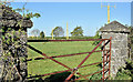
Field gate and landing lights, Killead (May 2017)
A field gate, between pillars made from concrete blocks, on the western side of Drennan’s Road Image These landing lights Image continue in the background.
Image: © Albert Bridge
Taken: 7 May 2017
0.23 miles