IMAGES TAKEN NEAR TO
Dungonnell Road, CRUMLIN, BT29 4DG
Introduction
This page details the photographs taken nearby to Dungonnell Road, BT29 4DG by members of the Geograph project.
The Geograph project started in 2005 with the aim of publishing, organising and preserving representative images for every square kilometre of Great Britain, Ireland and the Isle of Man.

There are currently over 7.5m images from over14,400 individuals and you can help contribute to the project by visiting https://www.geograph.org.uk
Image Map
Images are licensed for reuse under creativecommons.org/licenses/by-sa/2.0
Notes
- Clicking on the map will re-center to the selected point.
- The higher the marker number, the further away the image location is from the centre of the postcode.
Image Listing (1 Images Found)
Images are licensed for reuse under creativecommons.org/licenses/by-sa/2.0
Image
Details
Distance
1
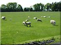
Field of sheep
Sheep and their fast-growing lambs grazing beside the Dungonnell Road. A few months ago some of these might well have been buried in a snowdrift during the severe weather.
Image: © Robert Ashby
Taken: 9 Jun 2013
0.07 miles