IMAGES TAKEN NEAR TO
Crosshill Road, CRUMLIN, BT29 4BH
Introduction
This page details the photographs taken nearby to Crosshill Road, BT29 4BH by members of the Geograph project.
The Geograph project started in 2005 with the aim of publishing, organising and preserving representative images for every square kilometre of Great Britain, Ireland and the Isle of Man.

There are currently over 7.5m images from over14,400 individuals and you can help contribute to the project by visiting https://www.geograph.org.uk
Image Map
Images are licensed for reuse under creativecommons.org/licenses/by-sa/2.0
Notes
- Clicking on the map will re-center to the selected point.
- The higher the marker number, the further away the image location is from the centre of the postcode.
Image Listing (5 Images Found)
Images are licensed for reuse under creativecommons.org/licenses/by-sa/2.0
Image
Details
Distance
1
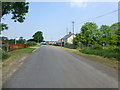
Crosshill Road, Ballynadrentagh
Heading NNW
Image: © Kenneth Allen
Taken: 6 Jun 2016
0.03 miles
2
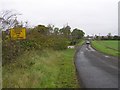
Crosshill Road
Heading NNW; the section of the road ahead is under the approach to Belfast International Airport
Image: © Kenneth Allen
Taken: 14 Oct 2009
0.04 miles
3
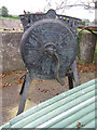
Bamfords Patent Perfect Root Cutter
This type of machine was used for slicing root crops such as mangle-wurzels and turnips for cattle feed. More at http://www.pallotmuseum.co.uk/contents/pages/mills/index.htm
Image: © Kenneth Allen
Taken: 14 Oct 2009
0.10 miles
4
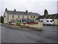
Crosshill Lodge
It is located along the Crosshill Road
Image: © Kenneth Allen
Taken: 14 Oct 2009
0.11 miles
5

Crosshill Townland
As you would expect, the ground near the airport approach is fairly flat
Image: © Kenneth Allen
Taken: 14 Oct 2009
0.14 miles