IMAGES TAKEN NEAR TO
Adelaide Street, BELFAST, BT2 8GB

Introduction

This page details the photographs taken nearby to Adelaide Street, BT2 8GB by members of the Geograph project.

The Geograph project started in 2005 with the aim of publishing, organising and preserving representative images for every square kilometre of Great Britain, Ireland and the Isle of Man.

There are currently over 7.5m images from over14,400 individuals and you can help contribute to the project by visiting https://www.geograph.org.uk

Image Map


Images are licensed for reuse under creativecommons.org/licenses/by-sa/2.0
Notes
  • Clicking on the map will re-center to the selected point.
  • The higher the marker number, the further away the image location is from the centre of the postcode.

Image Listing (2190 Images Found)

Images are licensed for reuse under creativecommons.org/licenses/by-sa/2.0
  • ...
Image
Details
Distance
1
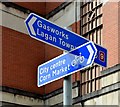
National Cycle Network sign, Belfast (June 2015)
Cycle route signs at Alfred Street, close to Russell Street Image
Image: © Albert Bridge Taken: 3 Jun 2015
0.01 miles
2
Belfast Bikes, Alfred Street (June 2015)
Bicycles, stands and payment meter on the Alfred Street side of the Clarence Court building.
Image: © Albert Bridge Taken: 3 Jun 2015
0.02 miles
3
Clarence Court, Belfast - August 2015 (1)
Government offices, at 10-18 Adelaide Street, completed in 1994 on what had once been the site of a bonded warehouse. See also Image
Image: © Albert Bridge Taken: 9 Aug 2015
0.02 miles
4
Clarence Court, Belfast - August 2015 (2)
See Image Detail from the upper floors. The building, designed by Ernest Knox Architects, had been conceived as a prestige (my word) headquarters for the Department of the Environment.
Image: © Albert Bridge Taken: 9 Aug 2015
0.02 miles
5
Alfred Street, Belfast
Alfred Street is part of the north-south axis of the grid pattern of the streets of central Belfast Image It runs from May Street Image to Ormeau Avenue. Once home to the linen and clothing trades it suffered during the bombing campaign but was re-born with new apartments, offices and nocturnal attractions (allegedly). An aside is that it, in common with many neighbouring streets, was named after members of Lord Donegall’s family (he was the landowner who granted leases for development).
Image: © Albert Bridge Taken: 21 Sep 2008
0.02 miles
6
Nos 27-37 Adelaide Street, Belfast
Save for Image, the former linen warehouse (second right) is probably the last building in Adelaide Street not renovated or demolished and replaced. Planning permission has been sought for “Regeneration and extension of vacant warehouse to include extension to rear, removal of floor 5, the incorporation of 4 new floors with a set back at levels 5 and 6 and 7 and 8. Uses to include retail (Class A1) and restaurant/ organic food hall on ground floor with canopy, 39 live work units on floors 1-4 and 7-8 and office use on floors 5 and 6. (Amended Plans)”. Image shows the building after conversion to offices.
Image: © Albert Bridge Taken: 28 Mar 2010
0.02 miles
7
View west along Russel Street
This one of few residential estates in the CBD of Belfast.
Image: © Eric Jones Taken: 15 Feb 2012
0.03 miles
8
Adelaide Street, Belfast
This road leads from the City Hall towards the Ormeau Road
Image: © Eric Jones Taken: 28 Mar 2017
0.03 miles
9
What a coincidence
Two BMW i3 electric cars, identical except for the colour schemes and wheel trim, top up at the charging point in Belfast's Adelaide Street.
Image: © Robert Ashby Taken: 27 Mar 2015
0.03 miles
10
Nos 27-37 Adelaide Street, Belfast (December 2013)
See Image (March 2010). The building (middle) remains untouched since the previous photograph.
Image: © Albert Bridge Taken: 15 Dec 2013
0.03 miles
  • ...