IMAGES TAKEN NEAR TO
Hulls Lane, LISBURN, BT28 2YY
Introduction
This page details the photographs taken nearby to Hulls Lane, BT28 2YY by members of the Geograph project.
The Geograph project started in 2005 with the aim of publishing, organising and preserving representative images for every square kilometre of Great Britain, Ireland and the Isle of Man.

There are currently over 7.5m images from over14,400 individuals and you can help contribute to the project by visiting https://www.geograph.org.uk
Image Map
Images are licensed for reuse under creativecommons.org/licenses/by-sa/2.0
Notes
- Clicking on the map will re-center to the selected point.
- The higher the marker number, the further away the image location is from the centre of the postcode.
Image Listing (15 Images Found)
Images are licensed for reuse under creativecommons.org/licenses/by-sa/2.0
Image
Details
Distance
1
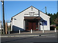
Lisburn Pentecostal Fellowship - Hull's Hill Hall
This modern hall replaces a metal structure formerly in use here.
Image: © Brian Shaw
Taken: 7 Nov 2005
0.12 miles

3
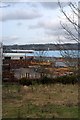
Corus Steel Service Centre
Corus Steel Service Centre, built over the site of the GNRI railway line from Knockmore Jct to Banbridge and Newcastle.
Image: © Wilson Adams
Taken: 18 Feb 2007
0.12 miles
4

Factory
Factory belonging to the McGrath Group.
Image: © Wilson Adams
Taken: 18 Feb 2007
0.12 miles

6

Approaching Lissue Crossing
17:17 Great Victoria Street to Newry Express approaching Lissue Crossing
Image: © Wilson Adams
Taken: 2 Apr 2004
0.12 miles
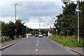
7

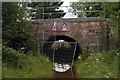
Hulls Lane
Hulls Lane that once joined the Moira Rd to the Lissue Rd, is now closed to road traffic. Beyond the bridge, is the site of the new Coca Cola Distribution plant.
Image: © Wilson Adams
Taken: 22 Jul 2007
0.12 miles
8
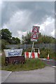
A Crooked Road Sign, Hulls Lane
A road sign advising motorists that the bridge ahead has a clearance of only 5'9" or 1.7 metres. Is this Ireland's lowest road bridge ?
Image: © Wilson Adams
Taken: 22 Jul 2007
0.12 miles
9
Halftown Road
Image made by standing in the middle of the road at Youngs Bridge located in grid Image Lissue Road straight ahead, Moira to the right, Lisburn to the left.
Image: © Wilson Adams
Taken: 22 Jul 2007
0.12 miles
10
Railway Bridge
Hulls Lane that once joined the Moira Rd to the Lissue Rd, is now closed to road traffic. Beyond the bridge, is the site of the new Coca Cola Distribution plant.
Image: © Wilson Adams
Taken: 22 Jul 2007
0.12 miles