IMAGES TAKEN NEAR TO
The Gallops, Lurganure Road, LISBURN, BT28 2QR
Introduction
This page details the photographs taken nearby to The Gallops, Lurganure Road, BT28 2QR by members of the Geograph project.
The Geograph project started in 2005 with the aim of publishing, organising and preserving representative images for every square kilometre of Great Britain, Ireland and the Isle of Man.

There are currently over 7.5m images from over14,400 individuals and you can help contribute to the project by visiting https://www.geograph.org.uk
Image Map
Images are licensed for reuse under creativecommons.org/licenses/by-sa/2.0
Notes
- Clicking on the map will re-center to the selected point.
- The higher the marker number, the further away the image location is from the centre of the postcode.
Image Listing (2 Images Found)
Images are licensed for reuse under creativecommons.org/licenses/by-sa/2.0
Image
Details
Distance
1
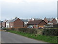
"The Gallops"
A new housing development of faux-Georgian houses has sprung up beside a formerly isolated bungalow.
Maze racecourse is just across the river Lagan to the south of the development, hence the name, I presume. In the townland of Lurganure.
Image: © Brian Shaw
Taken: 14 Mar 2007
0.20 miles
2
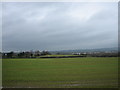
Lurganure townland.
Looking over an early crop (winter wheat?) towards the A3 between Lisburn (to the right) and Moira.
Image: © Brian Shaw
Taken: 14 Mar 2007
0.20 miles