
IMAGES TAKEN NEAR TO
Iniscarn Close, LISBURN, BT28 2BX
Introduction
This page details the photographs taken nearby to Iniscarn Close, BT28 2BX by members of the Geograph project.
The Geograph project started in 2005 with the aim of publishing, organising and preserving representative images for every square kilometre of Great Britain, Ireland and the Isle of Man.

There are currently over 7.5m images from over14,400 individuals and you can help contribute to the project by visiting https://www.geograph.org.uk
Image Map
Images are licensed for reuse under creativecommons.org/licenses/by-sa/2.0
Notes
- Clicking on the map will re-center to the selected point.
- The higher the marker number, the further away the image location is from the centre of the postcode.
Image Listing (36 Images Found)
Images are licensed for reuse under creativecommons.org/licenses/by-sa/2.0
Image
Details
Distance
1
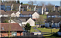
Iniscarn, Lisburn
Social housing between the Ballinderry Road (behind me) and the Causeway End Road.
Image: © Albert Bridge
Taken: 14 Apr 2013
0.03 miles
2
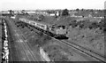
DL, Knockmore, Lisburn (1982)
103 “Merlin” on the third line, between Knockmore and the Causeway End Road bridge, with the 08.00 Londonderry – Belfast Central. See Image for a comparison 32 years later.
Image: © Albert Bridge
Taken: 29 May 1982
0.09 miles
3

Former Knockmore station, Lisburn (2)
This is the (closed) entrance to the platform on the right in Image It was served only by Antrim line trains. For comparison see Image (April 2013).
Image: © Albert Bridge
Taken: 13 Mar 2011
0.09 miles
4
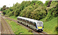
Diverted train, Knockmore, Lisburn - June 2014(1)
The railway was closed today between Belfast Central and Whiteabbey. Larne line passengers used a substitute bus between the two stations. Londonderry line trains were diverted via the mothballed Lisburn –Antrim line. C4K set 4002 has just passed the former Knockmore station Image and is climbing towards the Causeway End Road bridge with the 07.55 Coleraine – Belfast Central. This one Image (May 1982) makes an interesting comparison between the rolling stock and the growth of the lineside vegetation. Continue to Image
Image: © Albert Bridge
Taken: 1 Jun 2014
0.10 miles
5
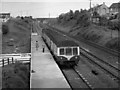
Train at Knockmore halt
One of NIR's MED sets pauses at Knockmore halt on the Lisburn - Antrim line with the 15.50 passenger train from Lisburn to Antrim, running 30 minutes late. Due to a long planning dispute, the direct line from Lisburn to the former Antrim branch junction at Knockmore did not open until 1977. However, the entire Lisburn - Antrim line closed on 29 June 2003 and is currently mothballed.
Image: © The Carlisle Kid
Taken: 14 Jun 1977
0.10 miles
6
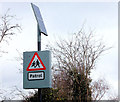
Solar panel, Lisburn
A solar panel powering flashing lights on a “school” sign, on the Ballinderry Road, just outward of the former Knockmore station Image
Image: © Albert Bridge
Taken: 13 Mar 2011
0.10 miles
7

Railway bridge, Knockmore, Lisburn
The four-arch bridge, carrying the Ballinderry Road across the Belfast (left) – Dublin line, seen from the path to the former Knockmore station Image
The far arch (never needed) was built in case the line from Knockmore Jct to Banbridge and Castlewellan was ever extended to Lisburn station. The middle two arches are for the Dublin line. The one nearest the camera was used by the third line to Antrim Image
Image: © Albert Bridge
Taken: 13 Mar 2011
0.10 miles
8
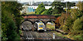
Former Knockmore station, Lisburn
The 11.15 Portadown – Bangor passing under the Ballinderry Road bridge. The closed Knockmore station Image and the “mothballed” third line Image and Image are on the right. The view is from the Causeway End Road bridge.
Image: © Albert Bridge
Taken: 19 Oct 2010
0.10 miles
9
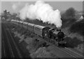
461 at Knockmore Halt
Preserved former DSER 2.6.0 No. 461 pulls away from the now closed Knockmore Halt as it approaches Lisburn on the currently "mothballed" line from Antrim.
Image: © The Carlisle Kid
Taken: 17 Feb 1991
0.10 miles
10
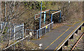
Former Knockmore station, Lisburn (2013)
See Image (March 2011). The skeleton of a shelter, on an overgrown platform, beside rusty track. Image shows how it looked in June 1977, before the shelter, when the line was open.
Image: © Albert Bridge
Taken: 14 Apr 2013
0.11 miles