IMAGES TAKEN NEAR TO
Hill Street, LISBURN, BT28 1YE
Introduction
This page details the photographs taken nearby to Hill Street, BT28 1YE by members of the Geograph project.
The Geograph project started in 2005 with the aim of publishing, organising and preserving representative images for every square kilometre of Great Britain, Ireland and the Isle of Man.

There are currently over 7.5m images from over14,400 individuals and you can help contribute to the project by visiting https://www.geograph.org.uk
Image Map
Images are licensed for reuse under creativecommons.org/licenses/by-sa/2.0
Notes
- Clicking on the map will re-center to the selected point.
- The higher the marker number, the further away the image location is from the centre of the postcode.
Image Listing (187 Images Found)
Images are licensed for reuse under creativecommons.org/licenses/by-sa/2.0
Image
Details
Distance
1
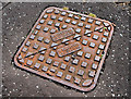
Mallon's manhole cover, Lisburn (2010)
See Image Another Mallon's cover, to a different design, at the Longstone Street end of the Governor’s Road. Image shows the maker’s name.
Image: © Albert Bridge
Taken: 24 Aug 2010
0.06 miles
2
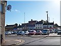
Lisburn's PSNI station from Lisburn Square
Image: © Eric Jones
Taken: 12 Oct 2012
0.09 miles
3
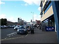
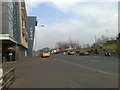
View west along Linenhall Street, Lisburn
Image: © Eric Jones
Taken: 12 Oct 2012
0.12 miles
4
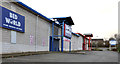
Retail warehouses, Lisburn
Two retail warehouses (one vacant and offered as a short-term let), at the bottom of the Laganbank Road Image Image shows the buildings after a major renovation.
Image: © Albert Bridge
Taken: 26 Dec 2011
0.12 miles
5
Linenhall Street, Lisburn
This is the view along Linenhall Street in Lisburn - with the City Library on the left and the wall of the postal depot on the extreme right.
Image: © Dean Molyneaux
Taken: 22 Apr 2008
0.12 miles
6
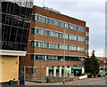
Lisburn Health Centre
Lisburn Health Centre, in Linenhall Street, opened in 1977. The photograph is slightly deceptive. The building has another (hidden) wing of approximately the same size. This building Image is on the left.
Image: © Albert Bridge
Taken: 26 Dec 2011
0.13 miles
7
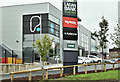
Retail warehouses, Lisburn (July 2017)
See Image (December 2011). The same buildings after a major renovation. The following planning permission (approved 29 February 2016) applies “LA05/2015/0633/F Proposed extension to existing building, upgrade of external elevations, and provision of a mezzanine floor to provide 2 No. Open Class A1 retail units and a gym (sui generis), reconfiguration of existing car park to provide a total no. 135 car parking spaces and provision of pedestrian crossing point (amended description). Laganbank Retail Park Laganbank Road Lisburn BT27 4TQ”.
Image: © Albert Bridge
Taken: 15 Jul 2017
0.13 miles
8
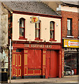
The "Hertford Arms", Lisburn
Long-established bar in Smithfield Street - how long is another matter. There is a record, in 1843, of the “Hertford Arms Hotel and Posting Establishment, George Davis, Proprietor” but there are also references to an establishment of the same name, around the same time in Railway Street. The name comes from the Hertford estate which owned much of the land around Lisburn. See also Image
Image: © Albert Bridge
Taken: 26 Dec 2011
0.13 miles
9
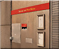
Letter box, Lisburn
The former Crown post office, in Linenhall Street, is now closed but the building remains as a delivery office. The slot for letters and small packets has been retained but the stamp machine has gone.
Image: © Albert Bridge
Taken: 14 Aug 2011
0.14 miles
10
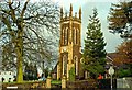
Christ Church, Lisburn
Not to be confused with the Cathedral Image this CoI parish church is on the Hillsborough Road. I have not been able to discover when it was built or the name of the architect.
Image: © Albert Bridge
Taken: 27 Jan 2009
0.14 miles