IMAGES TAKEN NEAR TO
Glenavy Mews, LISBURN, BT28 1NT
Introduction
This page details the photographs taken nearby to Glenavy Mews, BT28 1NT by members of the Geograph project.
The Geograph project started in 2005 with the aim of publishing, organising and preserving representative images for every square kilometre of Great Britain, Ireland and the Isle of Man.

There are currently over 7.5m images from over14,400 individuals and you can help contribute to the project by visiting https://www.geograph.org.uk
Image Map
Images are licensed for reuse under creativecommons.org/licenses/by-sa/2.0
Notes
- Clicking on the map will re-center to the selected point.
- The higher the marker number, the further away the image location is from the centre of the postcode.
Image Listing (5 Images Found)
Images are licensed for reuse under creativecommons.org/licenses/by-sa/2.0
Image
Details
Distance
1
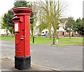
Pillar box, Lisburn
EIIR pillar box (BT28 6) at Knockmore Square. The Moira Road is in the background.
Image: © Albert Bridge
Taken: 8 Apr 2012
0.12 miles
2
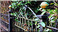
Old gate, Lisburn
A long-disused gate on the Ballinderry Road.
Image: © Albert Bridge
Taken: 13 Mar 2011
0.20 miles
3
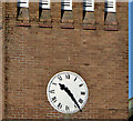
Clock, St Paul's, Lisburn
The clock (accurate), on St Paul’s (CoI) church Image, at the apex of the Moira and Ballinderry Roads.
Image: © Albert Bridge
Taken: 14 Apr 2013
0.20 miles
4
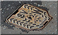
PAM stop valve cover, Lisburn
One of three PAM “Warrior” stop valve covers at the Ballinderry Road end of the Causeway End Road.
Image: © Albert Bridge
Taken: 14 Apr 2013
0.20 miles
5
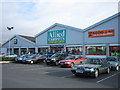
Shops
Three of four stores on a site off the A3 between Lisburn and Moira.
Image: © Brian Shaw
Taken: 16 Feb 2006
0.25 miles