IMAGES TAKEN NEAR TO
Waverley Avenue, LISBURN, BT28 1JS
Introduction
This page details the photographs taken nearby to Waverley Avenue, BT28 1JS by members of the Geograph project.
The Geograph project started in 2005 with the aim of publishing, organising and preserving representative images for every square kilometre of Great Britain, Ireland and the Isle of Man.

There are currently over 7.5m images from over14,400 individuals and you can help contribute to the project by visiting https://www.geograph.org.uk
Image Map
Images are licensed for reuse under creativecommons.org/licenses/by-sa/2.0
Notes
- Clicking on the map will re-center to the selected point.
- The higher the marker number, the further away the image location is from the centre of the postcode.
Image Listing (41 Images Found)
Images are licensed for reuse under creativecommons.org/licenses/by-sa/2.0
Image
Details
Distance
1
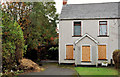
Vacant house, Lisburn (8)
Not, apparently, a development site, this house on the Hillsborough Road, is described on a property website as “The property is in need of some repair and refurbishment”. The photograph appears as a matter of record only. I have no connection with any of the parties involved in the sale.
Image: © Albert Bridge
Taken: 2 Oct 2011
0.05 miles
2

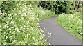
Celandine, Lisburn
Lesser celandine growing by the towpath beside the Lagan.
Image: © Albert Bridge
Taken: 31 Mar 2009
0.05 miles
3
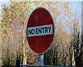
Old "No entry" sign, Lisburn
Old-style “no entry” at the exit from premises on this lane Image
Image: © Albert Bridge
Taken: 8 Nov 2010
0.06 miles
4
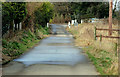
Path to the towpath, Lisburn (1)
Path (shown as “Hillsborough Road” on the Google map) leading from the Hillsborough Road (background) to the Lagan towpath Image Continue to Image
Image: © Albert Bridge
Taken: 12 Mar 2010
0.06 miles
5
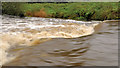
Weir, Lisburn (2)
The muddy Lagan, after some heavy rain recently, flowing over this weir Image, close to the old lock no 13 Image
Image: © Albert Bridge
Taken: 2 Oct 2011
0.08 miles
6

John Dory's Service Station, Hillsborough Road
Image: © Eric Jones
Taken: 12 Oct 2012
0.08 miles
7
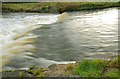
Weir, Lisburn
The weir, on the Lagan near the old lock Image The Lagan is flowing quite quickly a few days of rain.
Image: © Albert Bridge
Taken: 27 Jan 2009
0.08 miles
8
Spring towpath, Lisburn
Image: © Albert Bridge
Taken: 19 May 2013
0.08 miles
9
Vacant house, Lisburn (2)
A vacant house, facing the Hillsborough Road, with a long garden running down to the towpath. It has planning permission for demolition and replacement by apartments.
Image: © Albert Bridge
Taken: 12 Mar 2010
0.08 miles
10
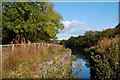
Disused lock near Lisburn
Disused lock no 13, on the Lagan Navigation, at Sprucefield looking towards Lisburn. This was part of a flight of four. It is well fenced to prevent access. Continue to Image Image shows the view from the Lisburn side.
Image: © Albert Bridge
Taken: 17 Oct 2007
0.08 miles