IMAGES TAKEN NEAR TO
Upper Ballynahinch Road, LISBURN, BT27 6XG
Introduction
This page details the photographs taken nearby to Upper Ballynahinch Road, BT27 6XG by members of the Geograph project.
The Geograph project started in 2005 with the aim of publishing, organising and preserving representative images for every square kilometre of Great Britain, Ireland and the Isle of Man.

There are currently over 7.5m images from over14,400 individuals and you can help contribute to the project by visiting https://www.geograph.org.uk
Image Map
Images are licensed for reuse under creativecommons.org/licenses/by-sa/2.0
Notes
- Clicking on the map will re-center to the selected point.
- The higher the marker number, the further away the image location is from the centre of the postcode.
Image Listing (4 Images Found)
Images are licensed for reuse under creativecommons.org/licenses/by-sa/2.0
Image
Details
Distance
1
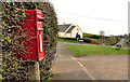
Letter box, Legacurry
Post-mounted EIIR letter box (BT27 4), on the Comber Road, at Legacurry Crossroads. Legacurry Presbyterian church Image is in the background.
Image: © Albert Bridge
Taken: 19 Mar 2012
0.14 miles
2
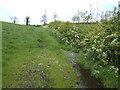
View north of the Legacurry Road
Image: © Jonathan Billinger
Taken: 17 May 2007
0.15 miles
3
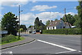
Legacurry village
Houses in the little hamlet of Legacurry.
Image: © Robert Ashby
Taken: 10 Jun 2015
0.16 miles
4
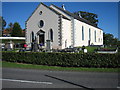
Legacurry Presbyterian Church
The foundation stone was laid in 1843, and the first Service held on 27 March 1844.
Image: © Brian Shaw
Taken: 13 Oct 2005
0.19 miles