IMAGES TAKEN NEAR TO
Saintfield Road, LISBURN, BT27 6UG
Introduction
This page details the photographs taken nearby to Saintfield Road, BT27 6UG by members of the Geograph project.
The Geograph project started in 2005 with the aim of publishing, organising and preserving representative images for every square kilometre of Great Britain, Ireland and the Isle of Man.

There are currently over 7.5m images from over14,400 individuals and you can help contribute to the project by visiting https://www.geograph.org.uk
Image Map
Images are licensed for reuse under creativecommons.org/licenses/by-sa/2.0
Notes
- Clicking on the map will re-center to the selected point.
- The higher the marker number, the further away the image location is from the centre of the postcode.
Image Listing (48 Images Found)
Images are licensed for reuse under creativecommons.org/licenses/by-sa/2.0
Image
Details
Distance
1
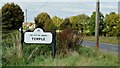
Name sign, The Temple near Carryduff (October 2015)
The name sign approaching The Temple from the Saintfield direction.
Image: © Albert Bridge
Taken: 17 Oct 2015
0.02 miles
2
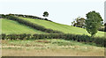
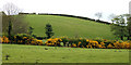
Drumlins, The Temple near Carryduff (October 2015)
Low mid-Down drumlins rising above dampish ground, at Carricknaveagh, on the northern side of the road from Saintfield.
Image: © Albert Bridge
Taken: 17 Oct 2015
0.04 miles
3
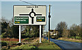
New roundabout, Temple crossroads - December 2016(1)
The new roundabout opened earlier this month. This sign, on the road from Saintfield, replaces the direction signs on the main road Image
Image: © Albert Bridge
Taken: 29 Dec 2016
0.08 miles
4
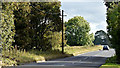
The Saintfield Road, The Temple near Carryduff (October 2015)
A straight and level section of an otherwise undulating and twisting road, from Saintfield to Lisburn, on the eastern side of The Temple crossroads.
Image: © Albert Bridge
Taken: 17 Oct 2015
0.08 miles
5
Drumlin near Carryduff
Just outside the main part of the drumlin belt, this one at Carricknaveagh, near The Temple Image, displays all the features of those from further south.
Image: © Albert Bridge
Taken: 27 May 2010
0.10 miles
6
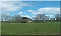
Farmhouse and farm buildings at The Temple
The image was taken from the A24.
Image: © Eric Jones
Taken: 27 Apr 2012
0.11 miles
7
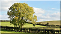
Solitary tree, The Temple near Carryduff (October 2015)
A solitary tree, among the mid-Down drumlins on the northern side of the Saintfield Road Image, displaying a delicate hint of autumn colour.
Image: © Albert Bridge
Taken: 17 Oct 2015
0.12 miles
8
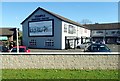
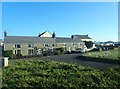
Shops at Temple Crossroads
This is an out of town shopping centre located at the crossroads of A24 and the Saintfield Road.
Image: © Eric Jones
Taken: 15 Oct 2018
0.16 miles
9
Terraced housing on the SW side of the Temple Crossroads
Image: © Eric Jones
Taken: 7 Dec 2018
0.16 miles
10
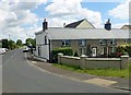
Terraced cottages at the Temple Crossroads
The cottages are at the corner of the A24 and the Saintfield Road.
Image: © Eric Jones
Taken: 21 Jun 2019
0.18 miles