IMAGES TAKEN NEAR TO
Carryduff Road, LISBURN, BT27 6TZ
Introduction
This page details the photographs taken nearby to Carryduff Road, BT27 6TZ by members of the Geograph project.
The Geograph project started in 2005 with the aim of publishing, organising and preserving representative images for every square kilometre of Great Britain, Ireland and the Isle of Man.

There are currently over 7.5m images from over14,400 individuals and you can help contribute to the project by visiting https://www.geograph.org.uk
Image Map
Images are licensed for reuse under creativecommons.org/licenses/by-sa/2.0
Notes
- Clicking on the map will re-center to the selected point.
- The higher the marker number, the further away the image location is from the centre of the postcode.
Image Listing (4 Images Found)
Images are licensed for reuse under creativecommons.org/licenses/by-sa/2.0
Image
Details
Distance
1

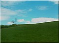
Drumlins on the east side of the A24 (Carryduff Road)
The land here is used mainly for hay making and grazing.
Image: © Eric Jones
Taken: 27 Apr 2012
0.10 miles
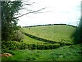
2
Telecommunications mast on the summit of a drumlin east of the Carryduff Road
Image: © Eric Jones
Taken: 27 Apr 2012
0.11 miles
4
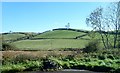
Mobile telephone mast south-east of the Temple Crossroads
This is located on the crest of a drumlin.
Image: © Eric Jones
Taken: 15 Oct 2018
0.24 miles