IMAGES TAKEN NEAR TO
Lisbane Road, LISBURN, BT27 6TY
Introduction
This page details the photographs taken nearby to Lisbane Road, BT27 6TY by members of the Geograph project.
The Geograph project started in 2005 with the aim of publishing, organising and preserving representative images for every square kilometre of Great Britain, Ireland and the Isle of Man.

There are currently over 7.5m images from over14,400 individuals and you can help contribute to the project by visiting https://www.geograph.org.uk
Image Map
Images are licensed for reuse under creativecommons.org/licenses/by-sa/2.0
Notes
- Clicking on the map will re-center to the selected point.
- The higher the marker number, the further away the image location is from the centre of the postcode.
Image Listing (12 Images Found)
Images are licensed for reuse under creativecommons.org/licenses/by-sa/2.0
Image
Details
Distance
1
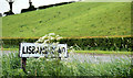
Lisbane Road sign near Ballynahinch
The sign at the end of the Lisbane Road Image where it joins the Belfast road, north of Ballynahinch. Partly hidden by cow parsley and grass.
Image: © Albert Bridge
Taken: 25 May 2010
0.01 miles
2

The western end of Lisbane Road
This image was taken from the A24.
Image: © Eric Jones
Taken: 10 Jul 2015
0.03 miles
3
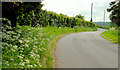
The Lisbane Road near Ballynahinch
A twisting section of the Lisbane Road Image as it approaches the Newcastle/Ballynahinch – Belfast road south of the Temple.
Image: © Albert Bridge
Taken: 25 May 2010
0.04 miles
4
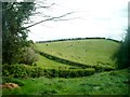
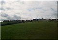
Drumlin near Ballynahinch
The side of a drumlin, on the western side the Ballynahinch – Belfast road, south of the Temple. Divided into fields by hawthorn hedges.
Image: © Albert Bridge
Taken: 25 May 2010
0.04 miles

6

House on Lisbane Road
The image was taken from the A24.
Image: © Eric Jones
Taken: 27 Apr 2012
0.11 miles
8
Drumlin-top farmhouse and buildings above the Carryduff Road
The buildings of this dairy farm overlook a large area of wetland with many lakes.
Image: © Eric Jones
Taken: 30 Jun 2015
0.15 miles
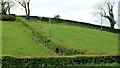
9

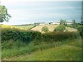
Drumlin slope hay field below hill-top farm buildings
Image: © Eric Jones
Taken: 30 Jun 2015
0.15 miles