IMAGES TAKEN NEAR TO
Bresagh Road, LISBURN, BT27 6TU
Introduction
This page details the photographs taken nearby to Bresagh Road, BT27 6TU by members of the Geograph project.
The Geograph project started in 2005 with the aim of publishing, organising and preserving representative images for every square kilometre of Great Britain, Ireland and the Isle of Man.

There are currently over 7.5m images from over14,400 individuals and you can help contribute to the project by visiting https://www.geograph.org.uk
Image Map
Images are licensed for reuse under creativecommons.org/licenses/by-sa/2.0
Notes
- Clicking on the map will re-center to the selected point.
- The higher the marker number, the further away the image location is from the centre of the postcode.
Image Listing (2 Images Found)
Images are licensed for reuse under creativecommons.org/licenses/by-sa/2.0
Image
Details
Distance
1
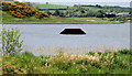
Lough Henney near Boardmills
An inter-drumlin lake, to the south of Boardmills, seen from the Bressagh Road Image The area was wooded (in common with many parts of Ulster) until the 17th century when the woods were cleared – partly for building materials needed to accommodate the influx of Scottish settlers and partly (it is said) to deprive those “on the run” (after the war of 1641/42) of hiding places. The black object is a ski-jump ramp.
Image: © Albert Bridge
Taken: 25 May 2010
0.21 miles
2
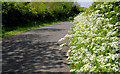
The Bressagh Road near Boardmills (2)
A part of the Bressagh Road Image, near Lough Henney, lined by a verge full of cow parsley.
Image: © Albert Bridge
Taken: 25 May 2010
0.23 miles