IMAGES TAKEN NEAR TO
Lough Road, LISBURN, BT27 6TT
Introduction
This page details the photographs taken nearby to Lough Road, BT27 6TT by members of the Geograph project.
The Geograph project started in 2005 with the aim of publishing, organising and preserving representative images for every square kilometre of Great Britain, Ireland and the Isle of Man.

There are currently over 7.5m images from over14,400 individuals and you can help contribute to the project by visiting https://www.geograph.org.uk
Image Map
Images are licensed for reuse under creativecommons.org/licenses/by-sa/2.0
Notes
- Clicking on the map will re-center to the selected point.
- The higher the marker number, the further away the image location is from the centre of the postcode.
Image Listing (6 Images Found)
Images are licensed for reuse under creativecommons.org/licenses/by-sa/2.0
Image
Details
Distance
1
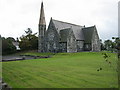
St Andrew's Parish Church
This Church of Ireland Parish Church is constructed of local basalt, and was consecrated on 20 April 1867.
Image: © Brian Shaw
Taken: 17 Oct 2005
0.19 miles
2
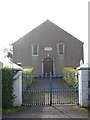
Former Killaney Presbyterian Church
Built in 1846, this is one of three Presbyterian Churches in the village which united in 2002 to form Trinity Boardmills Presbyterian Church.
Image: © Brian Shaw
Taken: 17 Oct 2005
0.19 miles
3
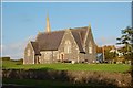
St Andrew's Parish Church near Boardmills
St Andrew’s, Killaney, (CoI) parish church was built in 1867 replacing an, earlier, smaller church.
Image: © Albert Bridge
Taken: 13 Oct 2007
0.19 miles
4
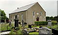
Trinity Presbyterian church, Boardmills (1)
Trinity Presbyterian church and graveyard beside the Church Road. Previously seen in Image (October 2005).
Image: © Albert Bridge
Taken: 21 Jun 2012
0.19 miles
5
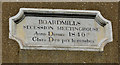
Trinity Presbyterian church, Boardmills (2)
The datestone.
Image: © Albert Bridge
Taken: 21 Jun 2012
0.19 miles
6
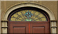
Trinity Presbyterian church, Boardmills (3)
The door and fanlight showing the burning bush.
Image: © Albert Bridge
Taken: 21 Jun 2012
0.19 miles