IMAGES TAKEN NEAR TO
Sandymount Close, LISBURN, BT27 5UB
Introduction
This page details the photographs taken nearby to Sandymount Close, BT27 5UB by members of the Geograph project.
The Geograph project started in 2005 with the aim of publishing, organising and preserving representative images for every square kilometre of Great Britain, Ireland and the Isle of Man.

There are currently over 7.5m images from over14,400 individuals and you can help contribute to the project by visiting https://www.geograph.org.uk
Image Map
Images are licensed for reuse under creativecommons.org/licenses/by-sa/2.0
Notes
- Clicking on the map will re-center to the selected point.
- The higher the marker number, the further away the image location is from the centre of the postcode.
Image Listing (46 Images Found)
Images are licensed for reuse under creativecommons.org/licenses/by-sa/2.0
Image
Details
Distance
1
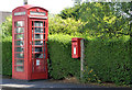
Telephone box and letter box, Ballyskeagh near Lambeg
Telephone box and post-mounted EIIR letter box (BT27 118) at Sandymount on the Ballyskeagh Road.
Image: © Albert Bridge
Taken: 19 Jul 2013
0.03 miles
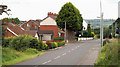
2

The Ballyskeagh Road near Dunmurry (3)
The road, looking towards Belfast, from near the entrance to McIlroy Park and the Lagan towpath.
Image: © Albert Bridge
Taken: 21 Aug 2010
0.04 miles
3
The Ballyskeagh Road near Dunmurry (2)
The road, looking towards Lisburn opposite the entrance to the football ground Image, approaching another bend.
Image: © Albert Bridge
Taken: 21 Aug 2010
0.04 miles
4
Fungi, Ballyskeagh - November 2014(2)
See Image Growing on top of the same stump. Image shows another, of the same species, on the same stump.
Image: © Albert Bridge
Taken: 15 Nov 2014
0.08 miles
5
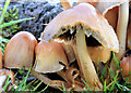
Fungi, Ballyskeagh - November 2014(3)
See Image Another example of the same species - on the same stump.
Image: © Albert Bridge
Taken: 15 Nov 2014
0.08 miles
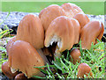
6
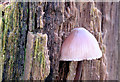
Fungi, Ballyskeagh - November 2014(1)
Growing on the side of a tree stump.
Image: © Albert Bridge
Taken: 15 Nov 2014
0.08 miles
7
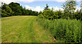
Trees, Ballyskeagh (2)
Recent planting in McIlroy Park, between the towpath and the Ballyskeagh Road (behind the trees at top left).
Image: © Albert Bridge
Taken: 18 Jun 2011
0.14 miles
8
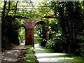
Ballyskeagh Bridge
Built c 1760 of local sandstone the bridge carries the Drumbeg to Lambeg road high above the now disused Lagan Canal.
Image: © Robert Ashby
Taken: 30 Aug 2010
0.15 miles
9
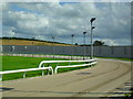
Greyhound Track, Drumbo Park
Frequently referred to as 'Ballyskeagh Dog Track' - Drumbo Park and the idea of a night at the dogs has increased in popularity over the last few years - this being the principal venue in the Greater Belfast region.
Image: © Dean Molyneaux
Taken: 15 Aug 2009
0.16 miles
10
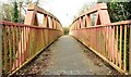
The Ballyskeagh High Bridge (5 of 8)
See Image This footbridge (on the northern side) allows pedestrians and cyclists to avoid the narrow road bridge. The view is towards Lisburn. Continue to Image
Image: © Albert Bridge
Taken: 26 Feb 2009
0.17 miles